On Monday 12th September 2016, the soil block was delivered to our Finds Lab where it could be assessed by specialist Finds Conservator Will Murray of the Scottish Conservation Studio. The plan was see how it could be carefully excavated and the artefacts conserved.
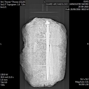 The soil block was then CT-scanned and x-rayed by the School of Veterinary Medicine at the University of Glasgow, with assistance from Gawain Hammond, Head of the Diagnostic Imaging Unit, and his team. The scan and x-ray provided valuable information and imagery to assist in the recovery of the items from the soil block. The x-ray shows that the bladed artefact is a sword and the gold decorated object is a large spearhead. But the x-ray also shows a pin lying across the handle of the sword.
The subsequent excavation of the soil block was undertaken over two weeks in November 2016 at GUARD Archaeology’s Finds Lab by GUARD Archaeologist Beth Spence, with Will Murray on hand to advise on the conservation of the artefacts.
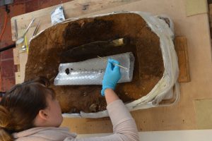 This excavation is one of the few times such a Bronze Age hoard has been undertaken in laboratory conditions. This is enabling every tiny scrap of artefact to be carefully recovered and recorded. The excavation has recovered, along with the sword and spearhead, a bronze pin and scabbard fittings (a chape to protect the tip of the scabbard and a ring that may have connected the scabbard to a belt.
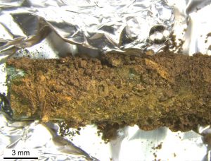
More than this, the excavation is revealing (and more importantly recovering) extremely fragile organic remains (including what looks like fur-skin and textile fragments) adhering to the bronze and gold artefacts. Finding such organic remains is EXTREMELY unusual, especially in a dry site like the one at Carnoustie (ancient organic remains often only survive in wetland, submerged or very dry conditions). The organic remains also include the sword’s wooden scabbard itself, which is very rare. In fact this is so rare a find, that the Carnoustie example is probably the best preserved Bronze Age wooden scabbard ever found in Britain.
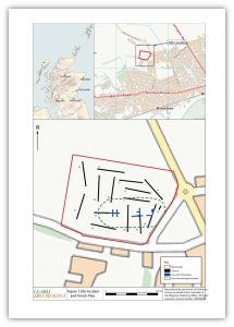
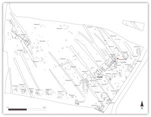 As the machine excavation of topsoil continued to reveal archaeological features so the archaeological excavation area continued to expand until by December 2016, the GUARD Archaeology team of nine archaeologists had discovered around 1000 archaeological features spread over a 17,700 sqm area.
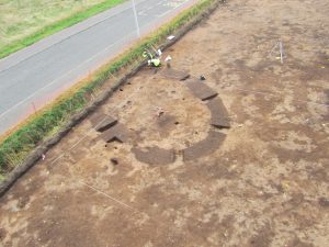 These features comprise numerous pits, post-holes and ditches. Many of these features are clustered together in patterns that can be recognised as house structures of various shapes, from elliptical, round and rectangular. From the various artefacts (pot sherds and flints mainly) that are beginning to be recovered, these houses appear to be prehistoric.
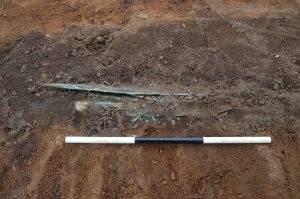 On Friday 9th September 2016, the GUARD Archaeologist monitoring the machine excavation of topsoil noticed something green just underneath the topsoil. Green is a sign of something with copper in it (like bronze) as this is the colour that oxidised copper turns. However, there was also a glint of gold, which is much more unusual (one of the reasons that gold is highly valued is that it doesn’t change colour like bronze or iron). While the green artefact appears to be a blade, the gold is decorated and appears to be part of a socket of another bronze artefact.
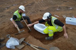 Owing to the fragile nature of these remains and that the site was going to be left open for the weekend, our team removed the entire pit (and the surrounding subsoil which it was cut into) as a single 80 kg block of soil. This was then delivered to our Edinburgh Office that same day, where it could be safely stored over the weekend.
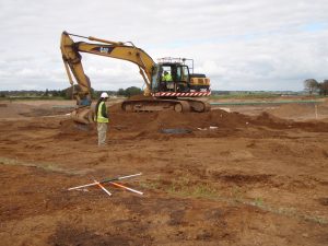
 Archaeological evaluations are often required for planning developments where there is a potential for unknown archaeology to be encountered and which would otherwise be destroyed by proposed development. Though there were no known archaeological remains within the development area,