Analysis of finds from the archaeological excavation carried out at Tigh Caol in Argyll last year by GUARD Archaeology Ltd have revealed startling new evidence for medieval travel and the impact of market forces and central government in the Scottish Highlands.
The archaeologists, led by GUARD Archaeologist Warren Bailie not only revealed the actual drovers' track nearby to the eighteenth/nineteenth century drovers' inn, that was the focus of the community research excavation, but also found a large area of in situ burning below the position of the track. This was identified as the burnt remains of birch logs which still had their bark on when laid on bare ground. Radiocarbon dating revealed that this dated to the thirteenth century was a 'corduroy' track whereby rows of wood, bedded with ash and sand, were used to consolidate a route taking heavy traffic through poorly drained ground.
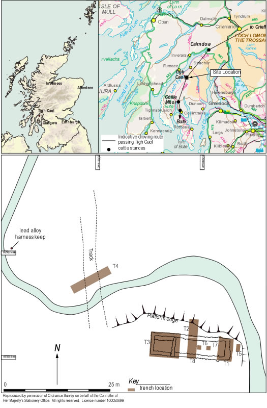
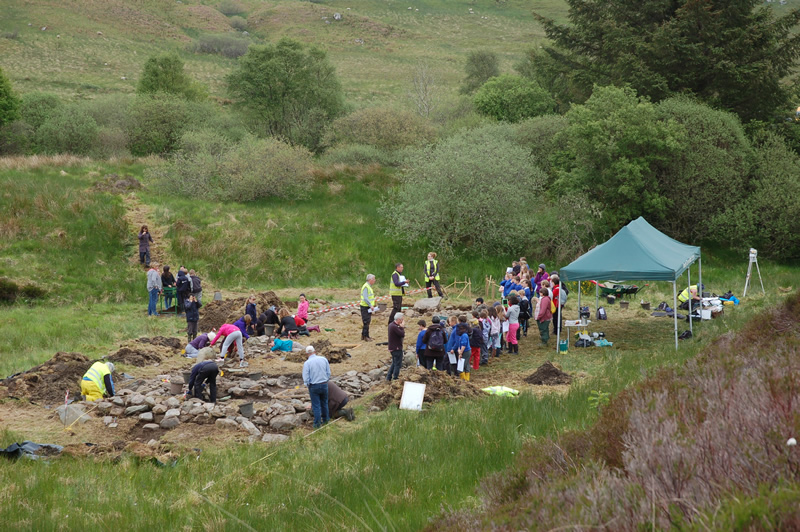
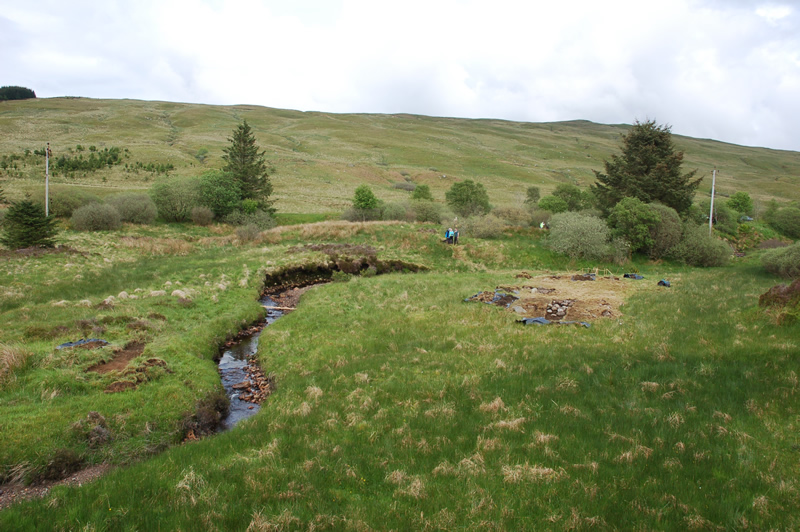
The excavations at Tigh Caol near Strathlachan in Argyll were undertaken on behalf of Dr Donald Adamson who had recently completed a study of droving routes in the Scottish Highlands. 37 volunteers from the Strachur and District Local History Society, students from the University of Glasgow and two metal detectorists as well as 100 local school children were involved in the dig which took place between 26 May and 6 June last year. The post-excavation analyses have now been completed and published to reveal the results of the work.
'The proposed area of investigation consisted of the ruins of what was formerly an inn in the parish of Kilmodan near Strachur, according to the Ordnance Survey Name Book of 1870,' said Donald Adamson. 'The site of Tigh Caol lies in a natural amphitheatre. This relatively sheltered site on the west edge of a burn had one main avenue of sight, towards the north along the drovers' road. The site was not readily visible when approaching from any direction until in close proximity. This setting for the inn would have offered a number of advantages including shelter, a readily available water source and passing trade on the drovers' road. The inconspicuous site could have also hidden away what may have been a place of unruly activity on occasion.'
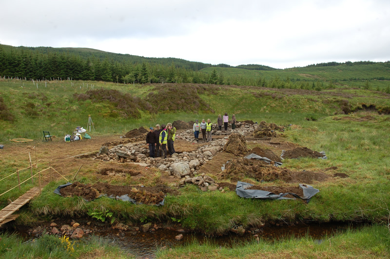
The investigations established that the building originally consisted of one long room with a later addition of a partition wall towards the west end. The excavation also recovered glass bottle and vessel shards and pottery sherds from the latter half of the eighteenth century, as well as a pewter harness keep with hour-glass design, a brass musket trigger guard, a possible late seventeenth- early eighteenth century horseshoe fragment and a George II coin dated 1727-1760.
'Evidence for structural changes to the building indicate that it may have originally been a post-medieval long-house then adapted for use as an inn,' said Warren Bailie. 'The central hearth set roughly in an earth floor is typical in post-medieval long-houses in Scotland and was still common in the late-nineteenth and early twentieth century. A new main entrance to the building was created on the north side, in full view of those approaching along the drove road. Other revealed details include a stone-built bench in the western room where chests and baggage were probably placed to protect them from moisture.'
As well as providing an insight into an eighteenth century drovers' inn, the evidence from the excavation addresses much wider themes in relation to what was driving change in the Scottish Highlands before and during Improvement. It seems that the building was not in operation much as an inn, if at all, before 1700, and ceased trading not long after 1800. As such, questions might be asked regarding why it was created and why it ceased to exist, especially since it was adjacent to an ancient trackway. One possibility is that whilst the routeway had always seen the passage of travellers, the much greater volumes of cattle using the route in the seventeenth and eighteenth centuries prompted the creation of the inn. Evidence from Crieff and Falkirk Trysts show that there was a very substantial expansion in cattle trading over this period. Perhaps this made a business viable when cattle rested in increasing numbers in the natural bowl around the building, sheltered and well watered, as they recovered from their ascent into the pass of the Caol Glen.
The investigations at Tigh Caol have also revealed a much wider time span for this site than was imagined before the dig. The timber corduroy track surface dates to the thirteenth century but there were several undated layers underlying this charred wood suggesting that this route could well have much older origins. Although the route was a drovers' road in the eighteenth and nineteenth centuries, it was likely to have been a highway for a long time before, from at least the thirteenth century, and in all probability well before that. The archaeological evidence also points to the route being used by far more than just drovers when Tigh Caol was trading as an inn in the eighteenth century. The range of quality in glass and pottery suggests use of the inn (and thus the route) by all social classes and for far wider purposes than just cattle droving.
A testament to the importance of this route across the high ground to the west coast of Argyll is the repeated improvements made to it: from a medieval track reinforced with birch corduroy, to a drovers' route repaired during the eighteenth century, to Telford's road in the early nineteenth century and the eventual A886 in the latter part of the twentieth century. Telford's road improved the route to such an extent that it may have triggered the demise of Tigh Caol inn. The new improved road not only physically detached the route from Tigh Caol but also reduced the need to stop on what was a faster route to market increasingly used by wagons and carriages. This is a scenario all too familiar today in our modern road systems, with bypasses being built around smaller communities in order to get to a main destination elsewhere more quickly and thus cutting off trade for that settlement.
Consequently, it seems that market forces, far removed from the Scottish Highlands, created a growing demand for cattle; and hence a greatly increased volume of cattle droves moving past the site; and thus an attractive proposition for someone to create the inn at Tigh Caol, at some point after 1700. Equally it could be held that external forces, in this case the activities of the Commissioners for Highland Roads and Bridges, removed the need for an inn at this location by the construction of a new road, and as a result the building became ruinous in the nineteenth century. Its demise would then relate directly to the growing power and influence of central government in the Scottish Highlands.
The full results of this research, ARO17: The demise of Tigh Caol, an eighteenth century drovers' inn by Donald Adamson and Warren Bailie, has just been published today, exactly one year after the excavations began, and is now freely available to download from the ARO website - www.archaeologyreportsonline.com.