GUARD Archaeology’s work exposing the heart of prehistoric Galloway has been nominated for Rescue Project of the Year in the 2022 Current Archaeology Awards!
Road to the past: exploring the prehistoric heart of Galloway is an account of our excavations of a range of Mesolithic, Neolithic, Bronze Age and Iron Age sites in advance of the Dunragit bypass. This work revealed around 8,000 years of human activity within a rich and complex historic landscape on the south-west coast of Scotland.
Voting for the awards opens today and will close on 7 February 2022 – the results will be announced on Current Archaeology’s Youtube channel on the evening of Friday 25 February 2022.
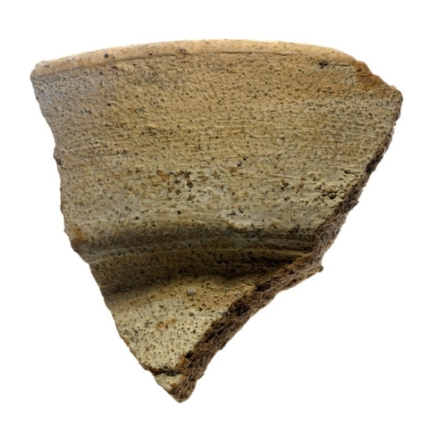
What GUARD Archaeologists discovered at Dunragit – the earliest known house in south-west Scotland, Neolithic ceremonial structures, two Bronze Age cemeteries and an Iron Age village – all the results are now published and free to download, either as a monograph or as a shorter booklet.
Alison Sheridan is a Research Associate at National Museums Scotland, whose primary research interests are Neolithic and Bronze Age Scotland. Alison is one of the specialist authors for the A75 Dunragit Bypass post-excavation works and is this month’s guest contributor to the blog.
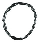
Arguably the most spectacular artefactual finds from the Dunragit excavations are two jet spacer-plate necklaces and a spacer-plate bracelet that came from two Early Bronze Age graves at East Challoch Farm. In this blog, I’ll try to explain how we got from this:
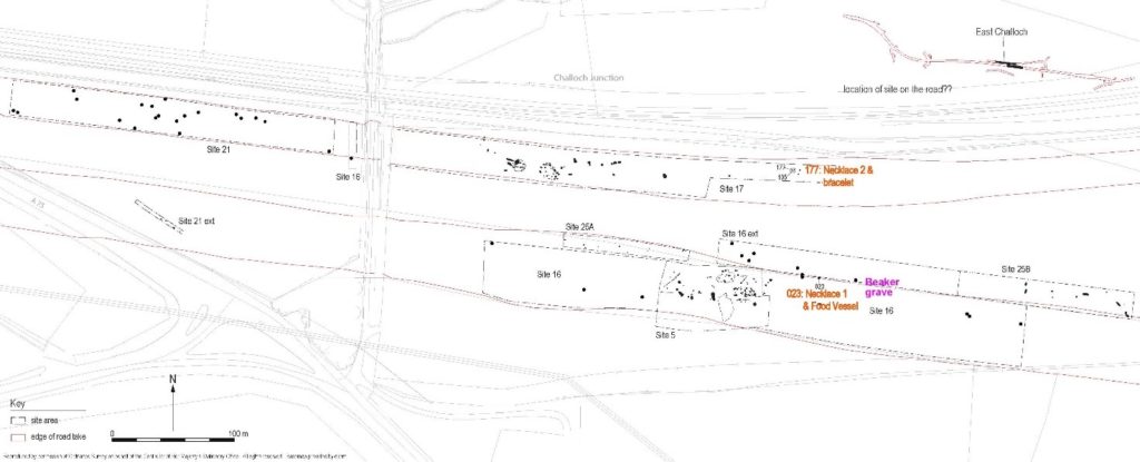
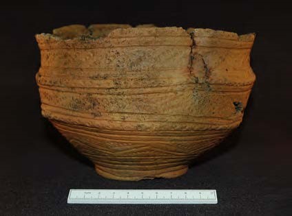
But first, the context: near East Challoch Farm, the GUARD Archaeology excavation team found several graves, including a grave with a Low-Carinated, All Over Cord Beaker, dating to 2500‒2336 BC (from hazel charcoal) – one of the earliest such graves in Scotland. The graves containing the jet jewellery are around 90 metres apart. While no meaningful radiocarbon dates could be obtained from them, we can say – from comparative dating of jet spacer-plate necklaces and from Food Vessels – that these graves most probably date to between 2150 BC and 2000 BC.
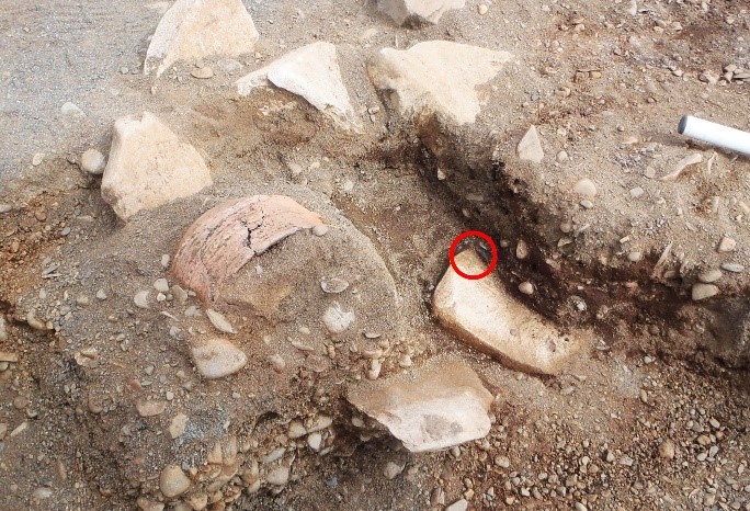
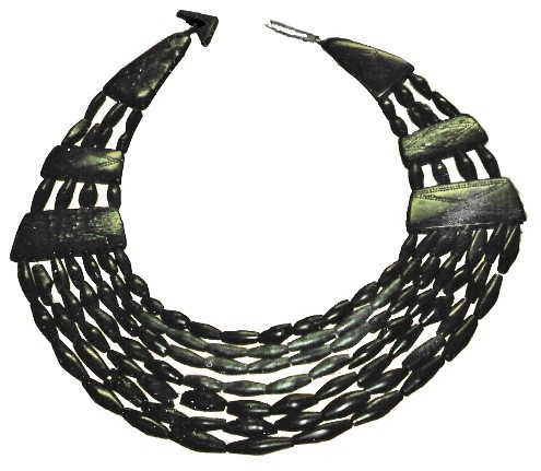
Jet Necklace 1: Grave 023 came to light when the side of a Food Vessel was revealed, at the south-east end of what turned out to be an oval, stone-lined grave orientated roughly NW/SE. The first few components of Necklace 1 to appear are ringed on the photo below. All that was found of the original occupant of the grave was a single fragment of unburnt bone, but since jet necklaces are associated with women, it’s likely that that person had been female.
The rest of the necklace was discovered when the Food Vessel was block-lifted. The rest of the necklace was discovered when the Food Vessel was block-lifted. The fact that several of the components lay in an arc, resting on a thin layer of sediment on the stones lining the base of the grave, made the task of reconstructing the necklace easier. It also indicated that the necklace cannot have been around the neck of the deceased: it had been deposited flat. The reasoning for this is that when necklaces were worn, their components end up more jumbled than seen here (as the other jet necklace from Dunragit shows); and the direction in which the arc is facing would make no sense for a body laid out along the long axis of the grave.
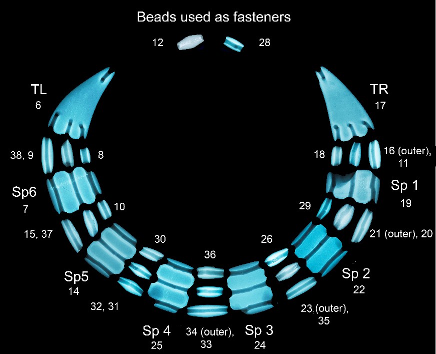
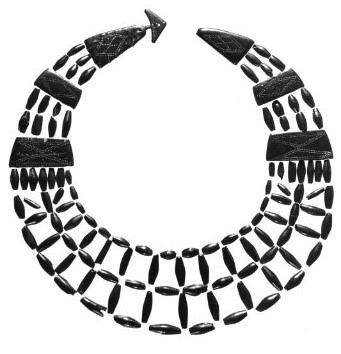
Each of the components was given a Small Find number. In all, the necklace consists of a pair of roughly triangular terminal plates (TL and TR), six spacer plates and 23 beads. Two of the beads must have served as fasteners, since there is only room for 21 beads in the three strands that ran between the plates. The original position of most of the components was fairly easy to work out, and while the positions of a few in the reconstructed necklace are conjectural, the fact that the beads generally increased in length from the inner to the outer strand means that the reconstruction below gives a faithful impression of how the necklace would originally have looked. The internal diameter of the necklace, as shown here, corresponds to the width of an adult female’s neck. Tightly strung, it will have sat on the neck looking like a fairly rigid collar.
No trace of the thread was found on any of the Dunragit jewellery. It will have been organic, strong enough to hold the components tightly strung as a collar, and narrow enough that all three strands could pass through the top holes on the terminal plates – the narrowest of which is around 2.2 mm. Sinew is one possibility, as are several plant-based threads (e.g. willow bast, nettle or linen). Wool would not have been used, since it wasn’t exploited until a particular breed of sheep had emerged, later on during the Bronze Age, and besides it might not have held its tension.
We don’t know how long the necklace would have had to be worn in order to produce the observed degree of wear, but it seems likely that it had not just been worn on special occasions. It might have been passed down over two or more generations, as a precious heirloom.
All the components are of jet, and it’s virtually certain that the necklace will have been made in or near Whitby in north Yorkshire – the only significant source of jet in Britain, and a known area where jet jewellery was made. We can tell it is jet from several characteristics: it’s black, light, warm to the touch, has taken a high sheen, and it has cracked in a characteristic way. Dr Lore Toralen’s compositional analysis using X-Ray Fluorescence has confirmed the identification: it has the high zirconium, low iron signature of much of Whitby jet.Parallels for this specific type of spacer-plate necklace, with just three or four strands interspersed with several large spacer plates, are relatively rare but include a necklace from Blindmill in Aberdeenshire and another from Middleton-on-the-Wolds in East Yorkshire.
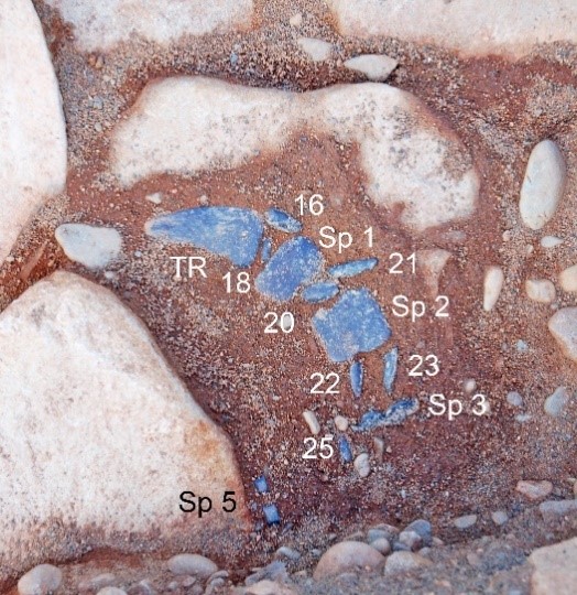
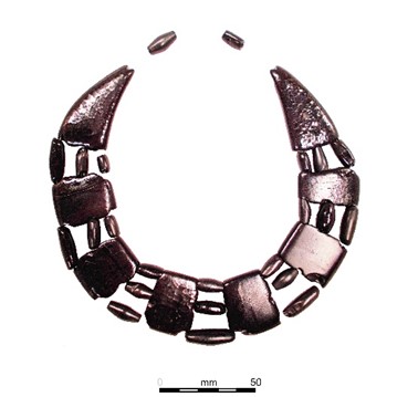
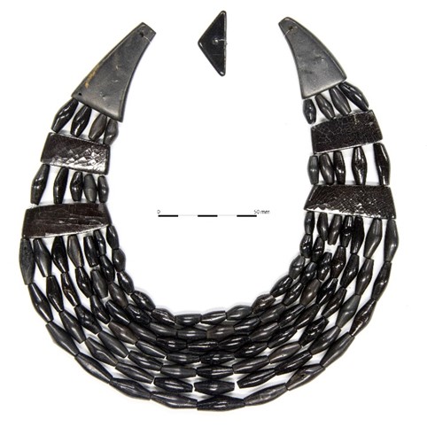
Jet Necklace 2 and bracelet: These were more complicated to reconstruct, because they had clearly been worn on the body in the grave, and as the body decomposed, the jewellery collapsed and its components became intermingled. There are also many more components than in Necklace 1. Necklace 2 consists of a triangular fastener, two terminal plates, a pair of upper spacer plates that increased the number of strands from four to five, a pair of lower spacer plates that increased them from five to seven, plus 108 fusiform (barrel-shaped) beads. The bracelet comprises two terminal plates and 20 beads, in two strands.
The grave 177 was orientated NE-SW, and the jewellery components were found at the NE end, slightly off-centre. No trace of the body survived in the grave, but from the position of the beads and plates there can be no doubt that an unburnt body – again, of a woman, to judge from other graves with spacer-plate jewellery – had been laid on her right side, in a contracted position, with the hands drawn up to the face. Her head was at the NE, looking NW.
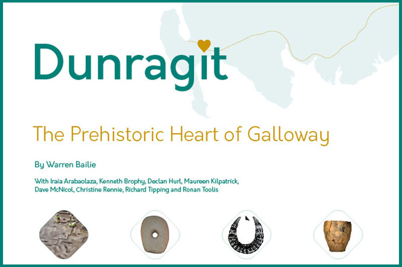
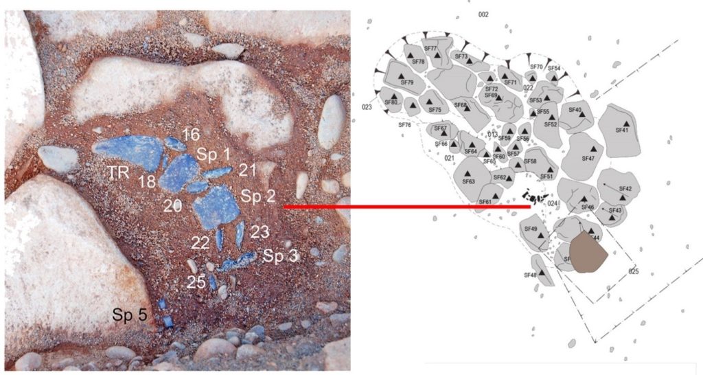
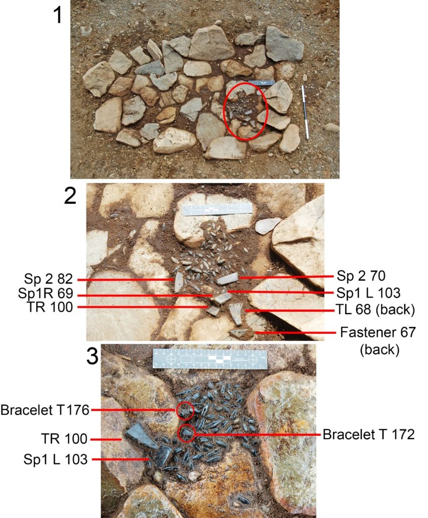
Photographs and plans that were created at various stages in the excavation showed how the necklace and bracelet had collapsed as the body decayed. While some components had been moved around a little, probably by the action of worms or rodents, by and large the beads and plates were in their original, post-decay positions.
Photo 1 above shows the mass of necklace and bracelet components indicating where the head and hands were lain.Photo 2 shows the topmost layer of beads and plates, annotated to identify the plates. Note that the triangular fastener and left-hand terminal (TL) have their undersides uppermost: this part of the necklace must have flopped to the floor of the grave when the thread decomposed. Photo 3 shows the next layer down. The TR is pointing away from the rest of the necklace – probably moved by worm or rodent action – and the upper left spacer plate (Sp 1L) that lay under its counterpart has been exposed. The fact that its outer surface is uppermost indicates that the head and shoulders had not lain at 90 degrees to the floor of the grave, but at a less acute angle – meaning that more of the necklace would have been visible to mourners looking in on the grave. Also visible on Photo 3 are the small triangular terminal plates of the bracelet, with SF 176’s perforated lower edge uppermost. The position of these and the bracelet beads, at a relatively low level, is consistent with the wrist in question being close to the neck, with beads from the necklace falling onto it as the body decayed.
As with Necklace 1, Necklace 2 and the bracelet are complete, and the consistency in the material, degree of wear and style of manufacture show that there had been no substitution of replacement elements, as sometimes happens with jet necklaces. X-Ray Fluorescence of one of the necklace beads confirmed that the material is jet, and it was noted that far fewer components showed the extensive surface criss-cross cracking that had been seen on Necklace 1.The beads and plates are far less worn than those on Necklace 1, which suggests that this set of matching necklace and bracelet had not been as old as Necklace 1 when it was buried. But, as we have seen, the necklace and bracelet didn’t look like this when found! It was necessary to do a complex, 3D jigsaw in order to arrive at the re-strung versions that you see here. How was this achieved? Just add time – weeks of it – and 30 years’ experience with Bronze Age jet jewellery…
As with Necklace 1, the inner diameter of the completed necklace corresponds to the width of an adult female’s neck; and this necklace, like Necklace 1, would have sat as a fairly rigid collar.
Necklace 2 is the commonest design of jet spacer-plate necklaces. Some have decoration on their spacer and terminal plates, but this one does not.
The presence of a bracelet, forming a matching set or parure, is rare but there is a good parallel from Campbeltown, and several others are known from Scotland. Normally just one bracelet is present, but at Melfort, just north of Kilmartin Glen in Argyll and Bute, a pair of magnificent sheet bronze bangles, with embossed designs in the shape of fusiform jet beads, was found.
The Dunragit Jet Set: These finds constitute the 55th to 57th examples of Early Bronze Age spacer-plate jewellery of jet (and of materials visually resembling jet) in Scotland. This jewellery was rare and precious, and served to signify the high status of the females who wore it. The Early Bronze Age in Scotland is the earliest time when obvious signs of female special status, such as these magnificent necklaces, were displayed in Scotland (and elsewhere).
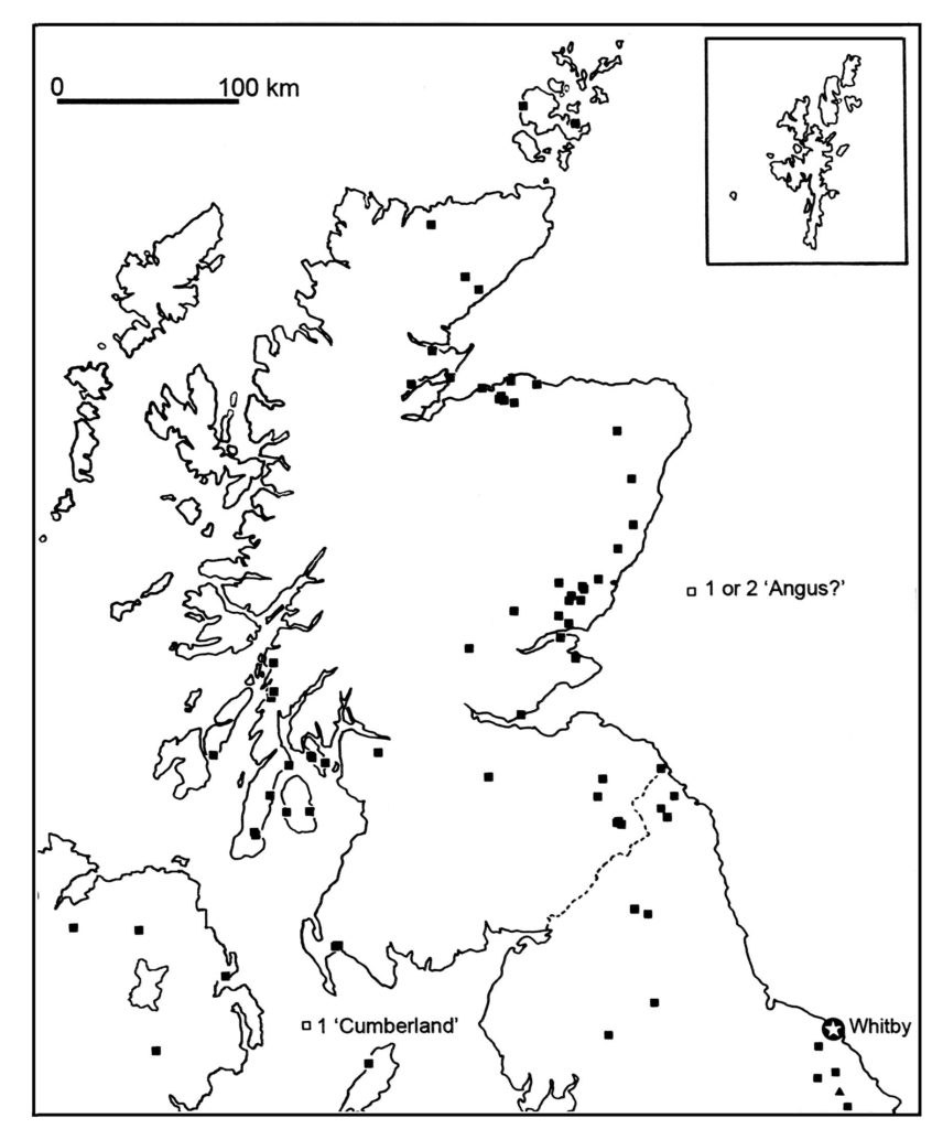
As you can see from the map below, there is a cluster of finds of spacer-plate necklaces a little to the north, around the Firth of Clyde and Kilmartin Glen, and a scatter of such necklaces to the west of Galloway in the north of Ireland, along with a recently-discovered example at Berk Farm, Isle of Man. It may be that the source of the wealth that enabled people in the Firth of Clyde and Kilmartin Glen to acquire these necklaces from Whitby was their control over the movement of Irish metal, which travelled up the Great Glen for bronzeworking around the Moray and Cromarty Firths. Other clusters, as in Moray and in Angus and Fife, are in rich agricultural areas. What enabled the Dunragit ‘jet set’ to acquire this precious and valuable jewellery? We don’t know; perhaps they, too, were involved with the movement of Irish metal. But it underlines the fact that the inhabitants of this part of Scotland were wealthy, and they participated in the dominant ‘vocabulary of esteem’ of the time. Jet-setters, indeed!
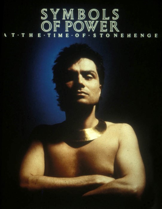
The kind of jet spacer-plate necklace that is Dunragit Jet Necklace 2 is a skeuomorph (i.e. copy in another material) of the Early Bronze Age gold lunulae which are known mostly from Ireland; a very few gold lunulae are known from Scotland. Here is one, featured on the poster for 1985, Symbols of Power at the Time of Stonehenge exhibition, at the then-named Royal Museum of Scotland.
It’s clear that both of the Dunragit necklaces, and the bracelet, were complete when buried, and they each consist of their original components, without any substitutions. Not all spacer-plate jewellery is found in such a complete state.
We are lucky that the Dunragit jewellery was excavated professionally and with the utmost care; many spacer-plate necklaces were found a long time ago, and dug up with little attention to the precise position of each of the components. One that was found in a cist at Poltalloch in Kilmartin Glen in 1928 was excavated (albeit as carefully as possible) with the aid of a piece of twisted wire, and since the excavator thought that the beads lay in a network pattern, the necklace was re-strung in that way (https://archaeologydataservice.ac.uk/archiveDS/archiveDownload?t=arch-352-1/dissemination/pdf/vol_063/63_154_181.pdf). That misconception influenced the way in which museums displayed these necklaces for most of the 20th century.
The detailed records made by the GUARD Archaeology excavators at Dunragit enable us not only to reconstruct the jewellery with a fair degree of accuracy, but also to appreciate the differences in the way it was buried, from one grave to the other: set aside from the corpse in the case of one grave, but worn on the body in another grave.
Fraser Hunter is the principal curator of Iron Age and Roman collections at National Museums Scotland. His primary research interests are understanding Iron Age decorative metalwork (“Celtic art”) in its European context, understanding the impact of the Roman world on the peoples of Scotland in its Empire-wide context and making the most of Iron Age material culture. Fraser is one of the specialist authors for the A75 Dunragit Bypass post-excavation works and is this month’s guest contributor to the blog.
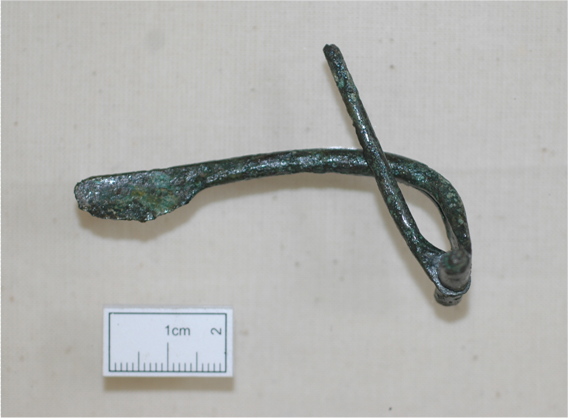
Sometimes on an excavation it’s the smallest of finds that can tell the biggest stories. The excavations of an Iron Age settlement at Myrtle Cottage on the Dunragit bypass produced a curious little bronze object, only 70mm long, inside one of the Iron Age roundhouses. It looks a bit like a safety pin, with an arched body hammered out of a piece of bronze, and a separate hinged pin that clicked it shut. When I first saw it, it puzzled me. It looked like a Roman brooch – but not a type I’d ever seen in Scotland. What was its story?
Dunragit Brooch
This is where the backroom work comes in. Making my way along a shelf of books covering all shapes and sizes of Roman brooches, I hunted it down. Now I realised what had puzzled me. Yes, this was a Roman brooch – but made well before the Romans reached Scotland.
The Roman army arrived in what is now Scotland in the late 70s AD. They probably got to this bit of Galloway in AD 80. But they reached southern England much earlier in AD 43. The invading legions didn’t just bring their swords and spears with them, but their brooches too.
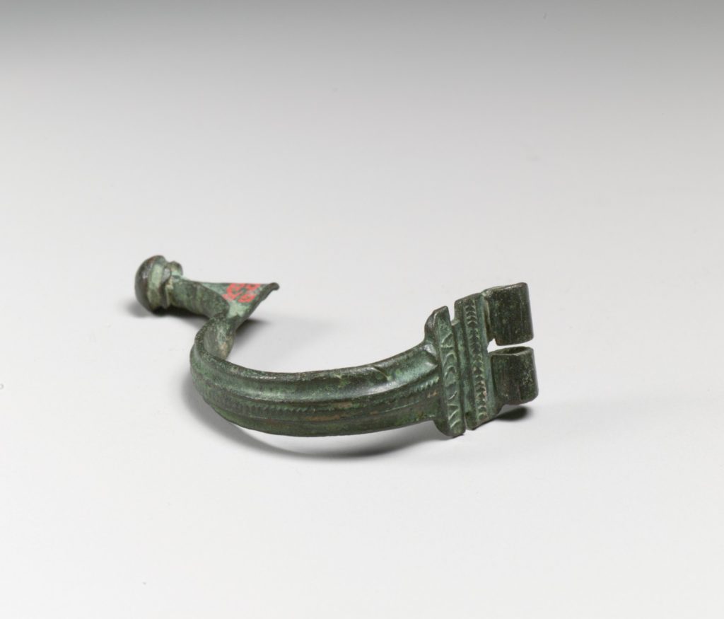
A popular military fashion at that time was a brooch made from a strip of brass. It was mass-produced in Gaul, and often stamped with the maker’s name, Aucissa. This ‘brand-name’ brooch was widely copied by other manufacturers. Subtle clues show that our brooch is one of these copies, made in Dorset, in southern England, in the years after conquest. The shape of ours isn’t right for an original Aucissa, which has a much higher arch to the bow; ours looks much more like these Dorset brooches. There are technical links too, such as the precise way that the pin was fixed, which match the English finds rather than the French ones. And there are clues from scientific work. We analysed the metal, and discovered it was bronze (an alloy of copper and tin), which was commonly used in Britain for brooches, rather than brass (a mix of copper and zinc), which was used for real Aucissa brooches. These brooches were made between the 40s and 60s AD, and had fallen from fashion by the time the Roman army reached Scotland.
Aucissa brooch (Metropolitan Museum of Art, New York; CCO 1.0)
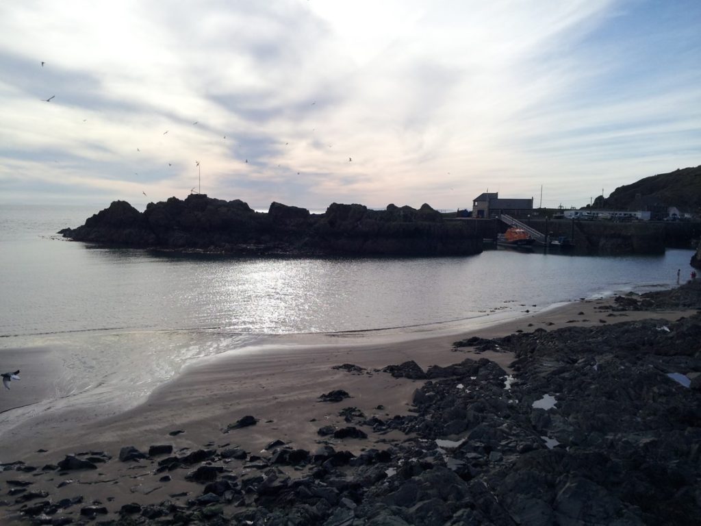
So … a Roman brooch that reached Wigtownshire before the Romans did. Why was it here? The findspot sits on the edge of Luce Bay – a place rich in archaeology. Stray finds from the sand dunes show that this area was well-connected in the Iron Age. The sea, not the land, was the easiest way to move any distance, and Wigtownshire was tied into seaways up and down the west coast. When you stand on the Wigtownshire coast, you look across to Ireland, England, and the Isle of Man. Jump in a boat and head south, and you’ll be in Cornwall in a couple of days. Some of the finds from the sands show links to south-west England – evidence of travel, trade and political links up and down the west coast. So perhaps the brooch travelled along long-established contact routes that travellers had followed for centuries, without the need for a travelling Roman.
Irish coast from Portpatrick
But there’s another possibility. Roman finds of this early date are very rare in Scotland, and they’re widely scattered, even reaching Orkney and Shetland. This looks less like casual visitors and more like a deliberate pattern – the residue of Roman scouting expeditions, exploring these northern waters in the years before conquest, making connections, finding who might be friendly and who wasn’t. It’s a lot of weight to put on one little brooch – but could it be a hint that the Romans were scouting out Wigtownshire in the years before the legions came?
Roman amphora sherd from Gurness in Orkney
So, ours is a brooch with a story. But there’s more to squeeze from it yet. Why did it survive? It’s unusual to find an intact bronze object like this, because bronze was precious and would be melted down and recycled. It seems unlikely that it was just lost – it came from a building that was otherwise kept pretty clean, not with piles of rubbish on the floor. Such an exotic item was probably valued and cherished, not abandoned as rubbish. I have another theory – that it was left there deliberately, as an offering. A lot of the nice, intact finds in our museums come from unexpected places – buried under buildings, left in lochs, placed in ancient cairns. This wasn’t carelessness or messiness, but purposeful acts. It seems people thought that sometimes an offering or sacrifice of a valued object in a special place was needed. We don’t know why. Perhaps it was to bring luck, or to thank the gods or the spirits for something. Perhaps it marked a rite of passage, when the owner went from child to adult, or single to married. In our case, it might have been left when the house was abandoned, as thanks for happy times or to remember its former owner. We don’t know – we can’t know, after almost 2000 years. But it was no accident. This little piece of bronze, a marker of contacts with a distant world, was deliberately placed in the old house as a valued and powerful object. It survived to tell its story – and not a bad story from such a strange little brooch.
Iraia
Arabaolaza is an osteoarchaeologist at GUARD Archaeology Ltd, whose primary
research interests arehuman pathologies and in particular childhood pathologies. Iraia is one
of the principal co-authors for the A75 Dunragit Bypass post-excavation works
and is this month’s guest contributor to the blog.
I have always believed that the study of human remains provides
a direct link to our prehistoric ancestors. As archaeologists we generally rely
on features (pits, structures, post-holes) and artefacts to try and reconstruct
a history of how people lived in the past. The study of human remains offers an
insight into a person’s biological sex, age, possible diseases that they suffered
during their lifetime and even in some rare cases the cause of their death. It
also provides an opportunity to better understand their belief system and
associated burial rituals.
Urn SF61 during excavation
All the human remains recovered and studied from Dunragit
were cremated and came from two sites, mainly Boreland Cottage Upper (27
cremations) with further three cremation remains from the Drumflower site. The
cremations were either placed in urns (the minority) or in pits as a cremation
deposit (the majority). No remains of pyres were encountered in the excavated
areas; however, charcoal remains recovered from the cremation deposits indicated
that it was mainly oak and alder that were used during the cremation rite. The
earliest cremations dated to the Early Bronze Age (approximately 2000 BC) and were
cremated using oak charcoal while the Middle Bronze Age cremations (approximately
1500 BC) used alder and other species including oak as fuel for their pyre.
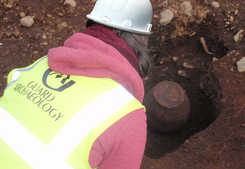
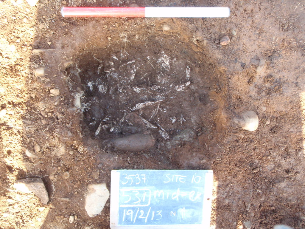
Cremation pit 531 during excavation
The cremated remains were fully calcified, as they were white in colour, which indicates that the bones were subjected to a high temperature between 645 -<940ºC. The surface texture of the bones, cracks and warping suggests that most bodies were not de-fleshed prior to burning, and that the bodies were burnt soon after death. A skull fragment recovered from an urn cremation showed green/blue staining which might indicate that the bone was in contact with a grave good with copper content. However, no grave goods were found within this particular cremation, apart from the urn that contained the remains, which indicates that the metal item was not deposited within the cremation burial.
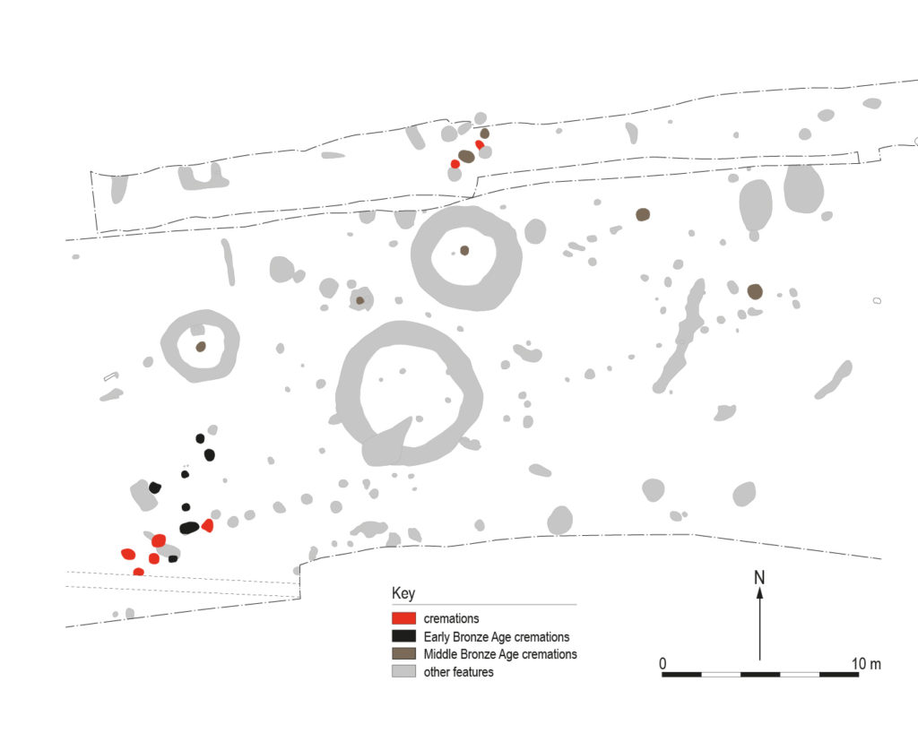
Plan of Boreland Cottage Upper cemetery complex
Most of the earlier cremation burials were small in weight and rather fragmented. This together with the lack or under representation of certain skeletal elements (i.e. shoulder, pelvis, rib cavity) suggests that most of the remains were possibly deposited as tokens in pits and were not representing a complete burial. Analysis based on the relative size of the bones indicated that most of the cremation deposits included the remains of at least one adult person. At Boreland Cottage Upper there was a clear change in the burial rite from a more clustered distribution in the earlier Bronze Age to more evenly distributed depositions concentrated around three ring ditches during the Middle Bronze Age. Moreover, multiple collective cremation burials were identified during this period. One urn cremation revealed two adults, one of them aged between 40-44 years and remains of a female while sub-adults or individuals younger than 18 years old were also identified buried together with an adult in three other burials. This is quite common in prehistory and could suggest they were cremated and deposited at the same time.
Several pathological conditions were noted in some of the human remains recovered from Dunragit. The pathologies included an unidentified healed infection/trauma and small bony growth, osteoarthritis on the spine and a possible sharp trauma/dismembering cut mark. Schmorls nodes, also known as intervertebral disc herniation, was also apparent – this is a lesion that appears in the vertebral body but usually causes no symptoms. Most of these are relatively easy to diagnose even on small fragments of archaeological bone and are common within the archaeological record. However, the cause of the possible infection/healed trauma remains unknown as its causes can be varied and are difficult to interpret without assessing the full skeleton. The possible cut marked bone is slightly more unusual although not unheard of from archaeological assemblages. The discovery of the cremation cemetery complex at Dunragit is of national significance. The quantity of cremations encountered in Dunragit (30), as well as the extensive use of the site for over 500 years has provided a rare insight into the Bronze Age burial practice in southwest Scotland. Although burial rites during the Bronze Age are characterised by their variety, there was clear distinction between the Early and Middle Bronze Age cremations found across the Dunragit site. While the earlier cremations were token symbolic depositions in pits, some of them with associated grave goods, the latter cremations were by and large the full remains, were associated with the ring ditch structures and were often contained in urns. Variations between these two populations in terms of their use of, and mobility within, the landscape were also apparent from the stable isotopes analysis on the cremations, but that will be another blog, while another forthcoming blog will cover the grave goods associated with these burial rites….
Alan
Cresswell is a Research Associate at the Scottish Universities Environmental
Research Centre, University of Glasgow, whose primary research interests are
luminescence analysis and dating of sediments in archaeological and
geomorphological investigations and wider interests in environmental
radioactivity and dosimetry. Alan is one of the specialist authors for the A75
Dunragit Bypass post-excavation works and is this month’s guest contributor to
the blog.
Optically Stimulated Luminescence (OSL) is an approach that can precisely date the deposition of sedimentary layers on archaeological sites. It utilises signals that develop in mineral grains in response to exposure to natural sources of ionising radiation from the surrounding sediments and cosmic rays. When radiation interacts with mineral grains, electrons within the mineral are excited into high energy states, some of which are metastable allowing this charge to be trapped. This trapped charge can be released by exposure to light or heat, emitting light, and with suitable equipment these photons can be counted. The number of photons counted can be related to the radiation dose the mineral had received by calibration in the laboratory using known radiation doses. The combination of received dose and the radiation dose rate gives a time since the trapped electrons in the mineral had last been released, which for materials deposited in many settings would correspond to the time that these minerals had been buried.
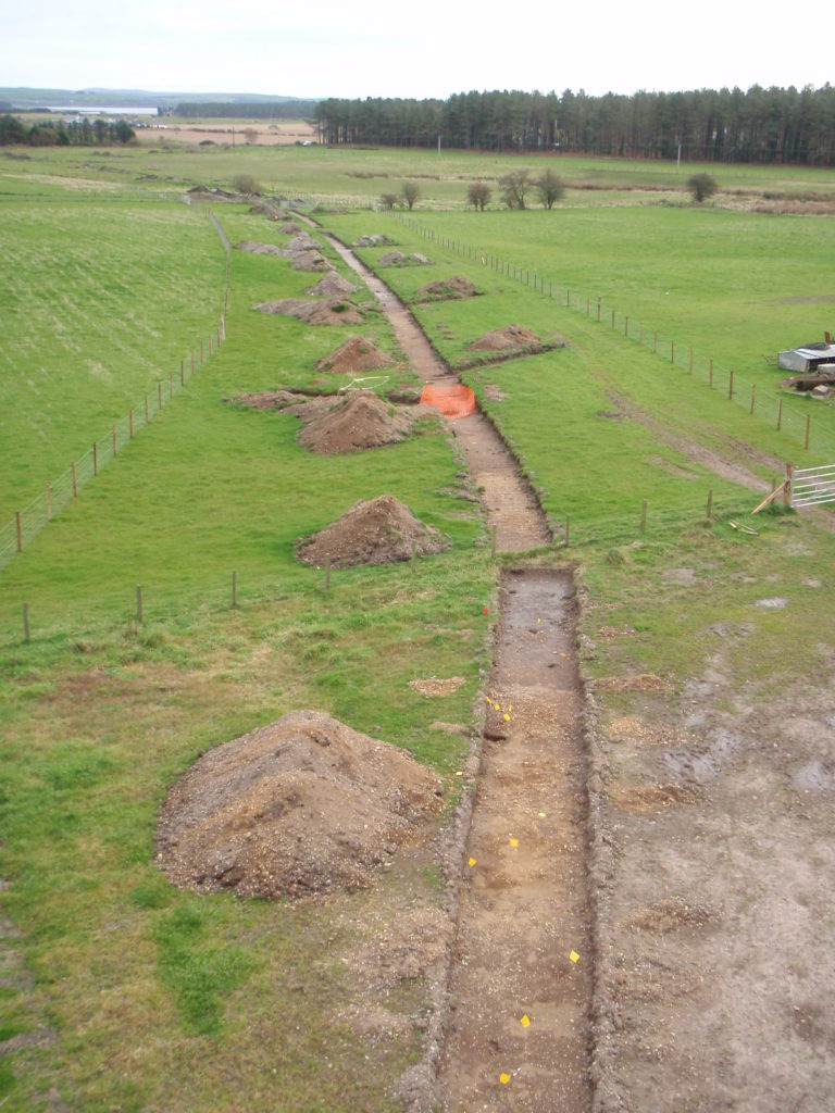
Investigations by GUARD Archaeology along the route of the A75 bypass at Dunragit included a set of roundhouses within a former dune system at Myrtle Cottage, with accumulated sand layers within and between these structures. As the Iron Age settlement unearthed at Dunragit was situated in an aeolian environment and as some deposits showed a paucity of organic material this method provided an opportunity for dating that would not otherwise be possible. Thirteen samples of sand were collected during the excavations from layers under structures 1 and 2, between the two structures, within the two structures and from the wall cuts. Quartz grains from these sands were analysed using OSL to determine whether the structures were contemporary, or if not, may indicate a sequence of construction for these two nearby structures.
The
layers beneath the structures consist of a natural layer dated to 3100 ± 650
BC, consistent with the mid Holocene tidal high stand for this section of the
Solway coast, and an occupation layer dated to 1540 ± 290 BC suggesting human
activity on the site significantly before the Iron Age. The wall cut for
structure 2 is dated to 350 ± 240 AD, and cuts through occupation layers dated
to 400-100BC and into the natural materials. Occupation layers outside structure
2 are approximately contemporary with the wall cut, potentially produced from
material excavated from this ditch. The wall cut for structure 1 is dated to
400 ± 190 AD but cuts through the layers outside structure 2, suggesting that the
construction of structure 1 slightly post-dates the construction of structure
2.
Overall, this dating evidence confirms the material culture that was recovered from the Iron Age settlement, which included an unusual Roman copper alloy brooch, an Iron Age iron penannular brooch and a rare, curved iron leatherworking knife of likely Roman Iron Age date. The Iron Age settlement at Dunragit, now dated to the centuries around the turn of the First Millennia BC/AD, is a welcome addition to a suite of settlements in Galloway that date to this specific period. These include the variety of settlements around Cults Loch, the large enclosed settlement at Rispain Camp and the promontory fort at Carghidown. These settlements provide useful dating, structural and material culture comparisons with the Iron Age settlement at Myrtle Cottage.
Torben Ballin is an independent lithics specialist and is one of the specialist authors for the A75 Dunragit Bypass post-excavation works. Torben is this month’s guest contributor to the blog.
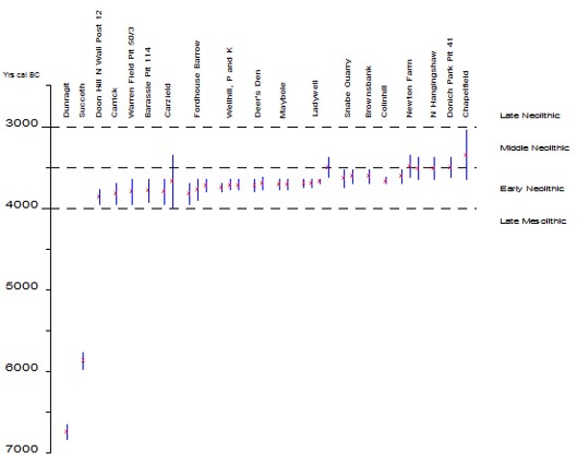
20,554 lithic artefacts were recovered from the excavations
at Dunragit, mostly of flint but also including some Arran pitchstone. These
objects were retrieved from a large number of mostly chronologically mixed
sites, dominated by Mesolithic and Middle/Late Neolithic material, but a small
number of sites were particularly interesting. They include a Mesolithic
settlement at West Challoch and a Neolithic/Bronze Age burnt mound at
Droughduil Bridge.
Mesolithic features at West Challoch
Although the 762-piece lithic assemblage from one of the clusters of features at West Challoch includes small amounts of intrusive later Neolithic finds, it generally forms a homogeneous Late Mesolithic assemblage dated to c. 6900-6800 cal BC. It was associated with a number of interesting features, such as a horseshoe-shaped structure, a cooking arrangement, and a number of large pits.
Mesolithic shelter at Fife Ness
In structural terms, the shelter is related to similar horseshoe-shaped structures from eastern Scotland, such as those from Fife Ness and Standingstones in Aberdeenshire.
Mesolithic shelter at Standingstones
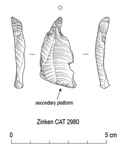
One radiocarbon-dated pit contained Arran pitchstone, one of only two Mesolithic Scottish radiocarbon-dated pits with pitchstone, where the large majority of pitchstone from pits has been dated to the Early Neolithic. Arran pitchstone is a type of volcanic glass similar to obsidian and in Scotland it is only found on the Isle of Arran in the Firth of Clyde. In Neolithic times it was traded as far north as Orkney and as far south as Dublin. The discovery at Dunragit of a Mesolithic pit with pitchstone has been interpreted as evidence of different forms of prehistoric exchange networks, where the Mesolithic was characterised by the exchange of individual pieces of pitchstone at a personal level, whereas the Early Neolithic exchange of pitchstone probably represents systematic exchange within a tribal system.
Scottish radiocarbon-dated pits with pitchstone
Zinken 2980 from West Challoch, Dunragit, Drawn by Jordan Barbour.
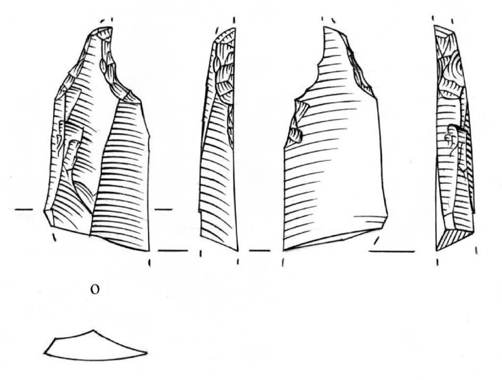
A total of 16,783 flints were recovered from another cluster of Mesolithic features at West Challoch, 580 of which are microliths and microburins. Microliths are tiny modified blades which in the Mesolithic were used as tips and edges of various forms of weaponry, and microburins are waste products from the production of microliths. These finds almost certainly date to the Late Mesolithic, and only one solitary, residual Hamburgian Zinken appears to be of another date. The Hamburgian artefact, as its name suggests, is a type known from sites in north-west Europe towards the end of last Ice Age around 14,000 years ago and Zinken are specialised blade-based piercers with a curved tip. Zinken only occur in Hamburgian contexts. Formally, this piece from Dunragit is similar to a slender Zinken retrieved in connection with the excavation of Howburn Farm in South Lanarkshire.
Zinken 5090 from Howburn Farm in South Lanarkshire. Drawn by Hazel Martingell. It measures 29 x 13 x 5 mm.
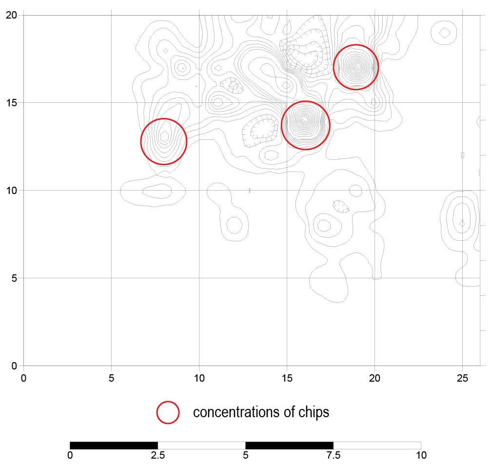
The distribution of chips across the site at West Challoch. The chips are waste produced in connection with the production of flint tools.
During the excavation, the finds appeared to form one large concentration, and the original working hypothesis was therefore that this might be the footprint of a hut of the same type as found on the coast of north-east England (at Howick) and south-east Scotland (at East Barns near Dunbar). However, distribution maps illustrating the distribution of individual finds categories (e.g., chips, burnt pieces, blades, microliths, etc) clearly showed that this was not the case, and that the finds probably represent 10-12 individual visits within a limited time-frame to a favoured spot in the landscape to knap flint, produce stone tools and process killed animals with the flint tools. The 200+ scalene triangles date the visits to sometime during the Late Mesolithic, that is 8400-4000 BC.
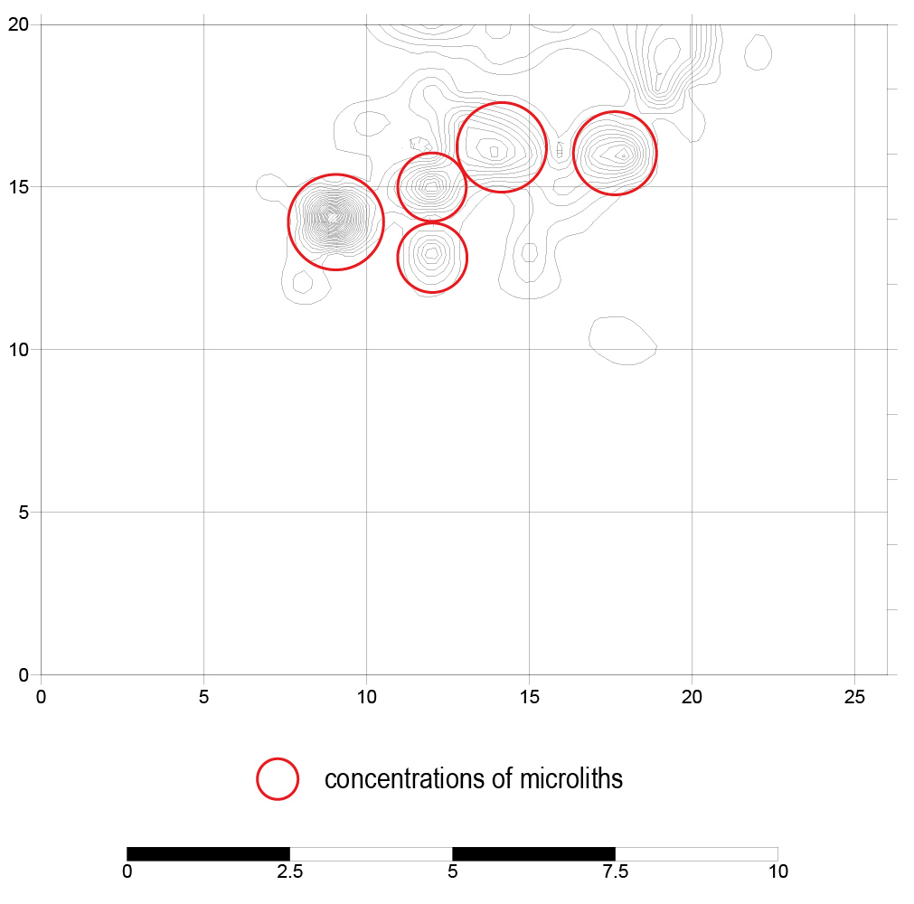
The distribution of microliths across the site at West Challoch. The microliths show where this form of weaponry was produced, with some of these pieces having been discarded during production and others possibly after having been damaged by use.
The excavation at Droughduil Bridge revealed a complex burnt mound with a trough that still had remnants of wood lining and a small sluice controlling water into the trough from a narrow cut channel. Burnt mounds are so-called because of the mound of burnt stone and charcoal that is typically found around a pit/or trough used to heat water with stones from a hearth. They are a very common form of monument and can be found across western Europe, Britain and Ireland from the Mesolithic through to the later Bronze Age, although they are typically associated with the Bronze Age period. Burnt stone and charcoal was recovered from the deposits within and around the trough. An assemblage of 569 flints was mixed into these various deposits, and the radiocarbon-dates are problematic with the basal fill of the trough giving a date of 353- 94 BC (Iron Age) and the channel leading into the trough giving a date of 974- 834 BC (Later Bronze Age). This is no doubt due to the water action on the feature, it being located in an estuarine environment. Whereas sediment can be eroded and redeposited, the lithic assemblage and its indicative date provide more certainty on the date of the activity at this burnt mound.
The assemblage is a homogeneous Middle Neolithic assemblage
of the kind known from Wester Clerkhill and Wester Hatton in Aberdeenshire,
including Levallois-like and bipolar cores and flakes, a chisel-shaped
arrowhead, end-scrapers and scale-flaked knives.
If the assemblage is contemporary with the burnt mound, this
defines the structure as one of the earliest of its kind and associated with
substantially more worked flint than these structures usually are. If not, this
is still a useful Middle Neolithic assemblage, adding to the knowledge of this
period. Further dates are being sought, this time using the in situ wood
pieces that remained of the wood lining, it is hoped this will provide a more
accurate date for the feature than the sediment provided.
Overall, analysis of the lithics from Dunragit, and
comparison of these finds with contemporary finds in eastern and western
Scotland allowed a number of questions to be discussed, and it was for example
possible to define a number of regional differences between the Mesolithic of
eastern/southern Scotland on one side and western Scotland on the other. In
eastern/southern Scotland, bipolar technique appears to have been used
sparingly during the Mesolithic and Early Neolithic periods, and this approach
only became a systematically applied reduction technique from the Middle
Neolithic onwards, to become particularly common during the Bronze Age. In
western Scotland, on the other hand, bipolar technique was used systematically
throughout prehistory. It is suggested, that this difference reflects
differences in lithic raw material availability, with flint being less
plentiful in the west and with flint nodules being considerably smaller in the
west.
Site
Region
Microliths, number
Microburins, number
Microlith:micro-burin ratio
1) Glenbatrick Waterhole
West
428
99
81:19
2) Lussa River
West
254
70
78:22
3) Lealt Bay
West
1,283
250
84:16
4) Nethermills Farm
East
431
620
41:59
5) Standingstones
East
61
59
51:49
6) Dunragit Site 19
South
358
206
63:37
The Table shows the microlith:microburin ratios of three sites from the west, two from the east and one from the south.
Another interesting difference is the use of microburin technique from the production of microliths during the Mesolithic, where this approach was used sparingly in the west and systematically in the east and south (see table above). It is suggested that this scenario is based on the following causal chain: Raw material (smaller pebbles in the west) Þ reduction technique (more use of bipolar technique in the west, resulting in thicker, more irregular microblade blanks) Þ microlith technology (less common use of microburin technique in the west). A comprehensive lithics report will form part of the forthcoming Monograph.
Dr Kenny
Brophy is a senior lecturer in Archaeology at the University of Glasgow, whose primary
research interests arepublic archaeology, contemporary archaeology and the Neolithic of Britain.
Kenny is the Academic Editor for the A75 Dunragit Bypass post-excavation works
and is this month’s guest contributor to the blog.
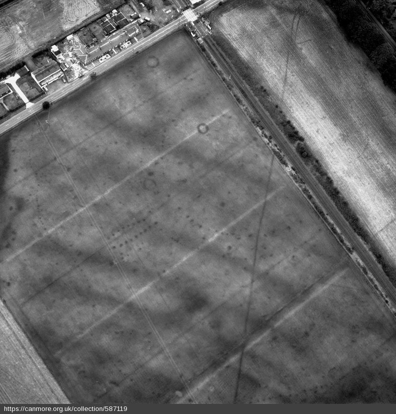
In the summer of 1999, twenty years ago, I drove down to Wigtownshire to spend a week’s holiday from my job with the aerial survey team of the former Royal Commission on the Ancient and Historical Monuments of Scotland (RCAHMS), now Historic Environment Scotland (HES), to help with a major excavation at one of the most significant Neolithic cropmark complexes in Scotland – Dunragit. This is a site that had already been close to my heart for a long time, as a Neolithic researcher and cropmark obsessive. I had even been asked on to a show on BBC Radio Scotland to talk about the significance of the cropmarks and why they were ‘Scotland’s Stonehenge’ (clue: they are not!).
The chance
to work with Julian Thomas (now Professor of Archaeology at Manchester
University) again was also too good to miss, having served as site supervisor
for him at his excavations at Holywood cursus complex and Holm Farm in the two
previous summers, both also in Dumfries and Galloway. During my week at
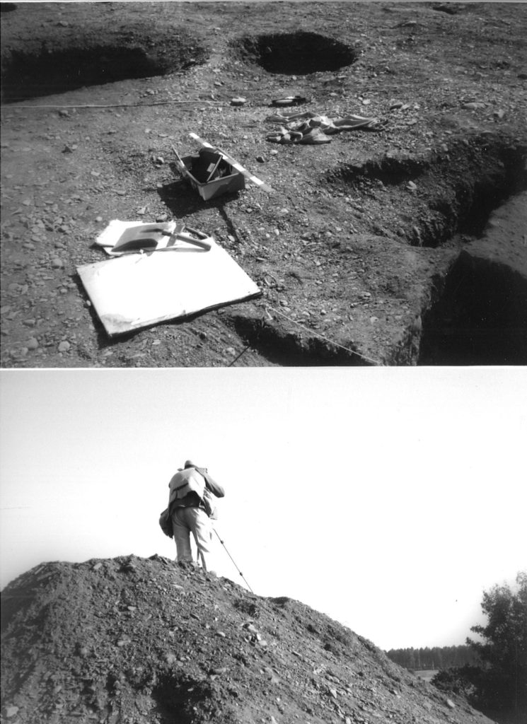
Dunragit, I got to dig some Neolithic post-holes which is one of the most
pleasurable ways possible to spend a summer’s day!
Two of my photos taken at the Dunragit excavations in 1999 (photos: K Brophy)
I have been
thinking a lot about this site and that summer recently, because I am now advising
GUARD Archaeology on the post-excavation and writing up of their excavations
along the route of the new A75 Dunragit Bypass. The significant discoveries
made along this road corridor are adding a huge amount of information, depth
and context to Thomas’s excavations of the main cropmark complex, published in
his 2015 book A Neolithic ceremonial complex in Galloway. Amongst other
things he excavated parts of an early Neolithic timber cursus monument
(rectangular enclosure dating to about 3800 BC) and a huge triple-boundary
timber palisaded enclosure of the late Neolithic (2800-2600 BC); all of this
archaeology had been recorded as cropmarks. GUARD Archaeology’s work has added
to this considerably.
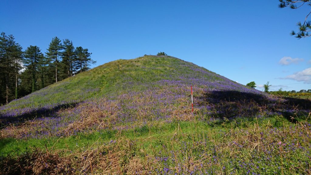
Droughduil Mote, in May 2019 (photo: K Brophy)
It was a recent visit to Dunragit with the Neolithic Studies Group that brought home to me the significance of GUARD Archaeology’s discoveries. We visited the Droughduil Mote, a huge flat-topped mound to the south of the main cropmark area. Thomas excavated this (with a minibus load of students from my archaeology department at Glasgow there to help) in 2002, on a hunch, because the mound was aligned upon by the entrance avenue to the Neolithic enclosures he had been excavating to the north. It turned out to be a sand dune that was artificially enhanced in the Neolithic period, an enormous endeavour to create a viewing platform to overlook ceremonies and rituals being carried out nearby. The excavations undertaken for the A75 Dunragit Bypass project in the area between the Droughduil Mote and the Neolithic enclosures of Dunragit and will hopefully shed some light on the activities that took place here in the Neolithic period.
One thing
Julian was not able to determine during his three seasons of excavations was –
what was going on between the timber enclosures he investigated at Dunragit and
the big mound in prehistory? Cropmarks had not been able to fill in the detail
of this flat area and a gap of a few hundred metres. A gap now filled by the
A75 Dunragit Bypass!
The route of
the bypass enabled excavations to take place in this area, known as Droughduil
Holdings, in 2014, to help begin to solve the mystery of what lay between the
Neolithic timber enclosures at Dunragit and the Mote mound. Right across the
road corridor zone, effectively sampling this part of the Neolithic landscape,
dozens of pits and post-holes were found. The post-excavation work currently
being undertaken by Transport Scotland and GUARD Archaeology will provide dates
for this activity, but it seems likely that Neolithic activity is represented
here, with possible alignments and even structures identifiable, which will
shed light – we hope – on how people were navigating this part of the landscape
in the Neolithic period, perhaps part of ritual processions.
View east along investigation area at Droughduil Holdings (GUARD Archaeology)
The A75 archaeological work as a whole will add a huge amount to our understanding of the major Neolithic complex at Dunragit, but also expand the time-depth of our knowledge of this place, with major Mesolithic, Bronze Age and Iron Age discoveries made in the vicinity. Dunragit and Droughduil is not just a Neolithic story but goes back centuries before and runs on centuries after the monuments Julian Thomas focused on. We have come a long way in 20 years. Back then Dunragit was only a set of dark marks amongst the crops on air photographs, a site of potential but essentially an area where the archaeology was as yet poorly understood. Thomas’s excavations got the ball rolling, but it took the broader landscape sampling offered by the construction of the new bypass to open up insights into the context of the timber enclosures.
In turn, the amazing discoveries made by GUARD Archaeology on behalf of Transport Scotland will help us not just better understand what was happening at Dunragit thousands of years ago, but also help us say lots of new things about Scotland in prehistory.
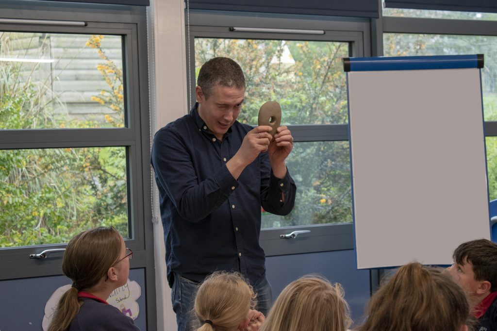
Communicating the results of our work to as wide an audience as possible is one of the key principles of GUARD Archaeology and accords with Scotland’s Archaeology Strategy. So, it was with great pleasure that a team of GUARD Archaeologists led an engagement event at Glenluce and Castle Kennedy Primary Schools on 30th April 2019.
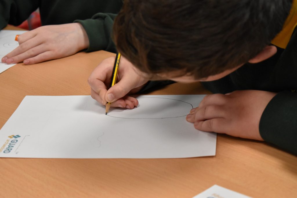
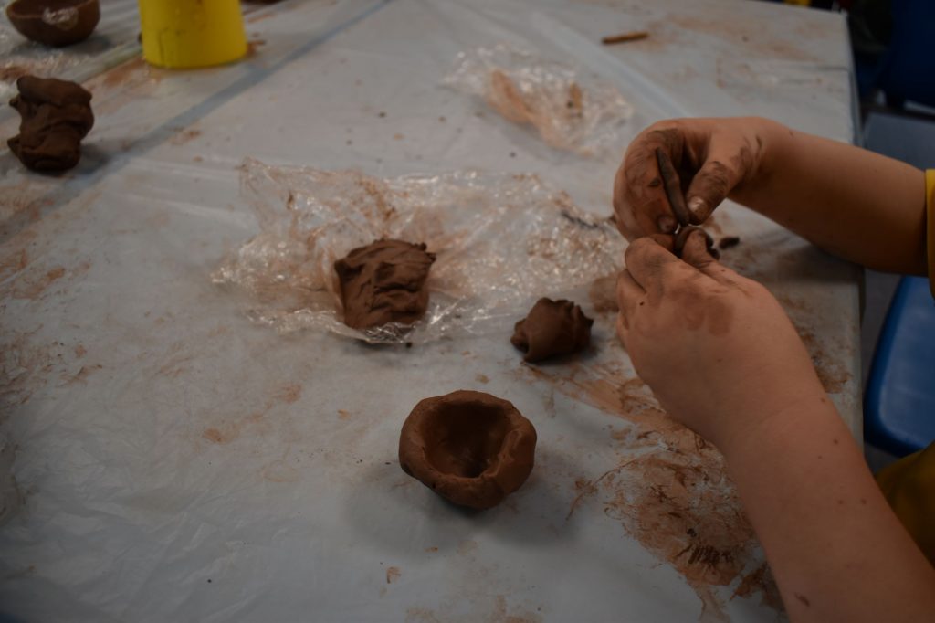
There were 56 children
from P5, P6 and P7 across both schools involved in clay modelling and paper craft
activities led by GUARD Graphics Officers Gillian Sneddon and Jennifer
Simonson. We took along one of the conserved pottery vessels and numerous stone
tools from the excavations associated with the A75 Dunragit Bypass, to use in
the activities.
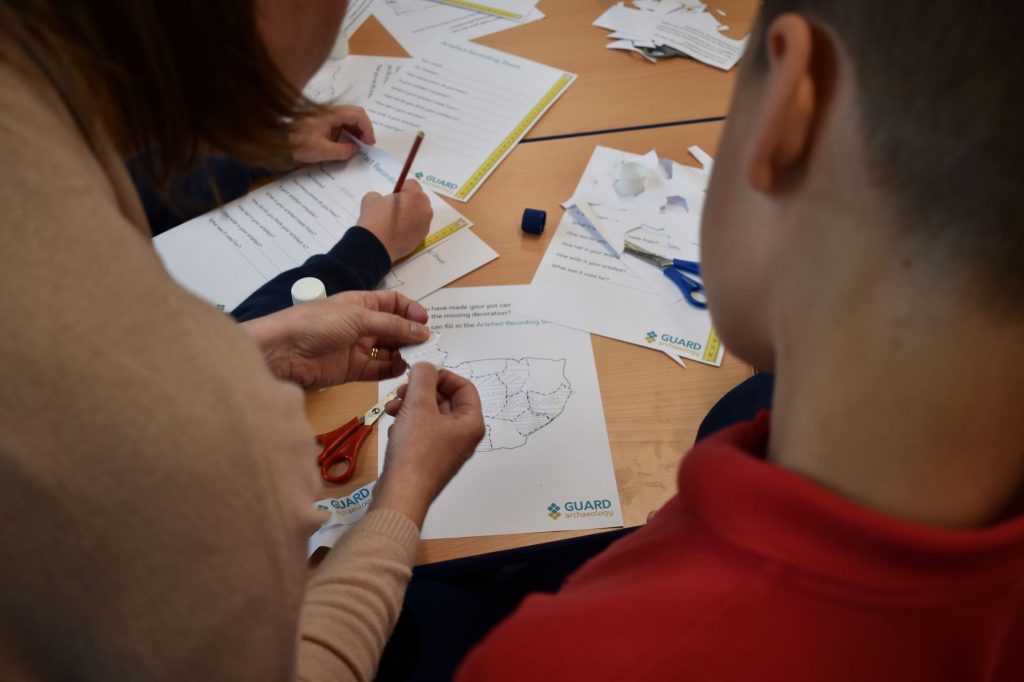
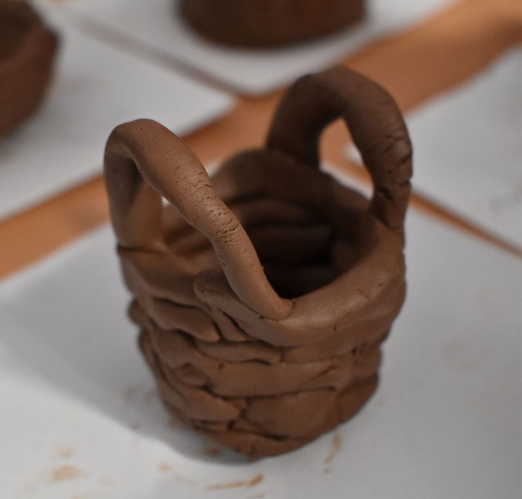
One of the activities the children undertook was the paper recreation of the pot from cut-out paper fragments which were glued together to form the outline of the vessel. They also learned how to record notes on the pot – what it was made from, its decorative details and its age. They then coloured in the same pot adding their own take on the decoration. This was followed by clay modelling where the same children had to try to recreate the vessel using air-drying clay and modelling tools that may have been used for the original, such as twigs, cord, feathers etc. The children created some very individual-looking pots with their own personal touches.
James Ferguson, Acting Head Teacher at Glenluce and Castle Kennedy Primary Schools commented that, ‘The children really enjoyed the experience and were stimulated by the range of activities, which raised their awareness of the historical significance of their locality.’
‘This was a valuable opportunity to engage with the local school children and to teach them about the significant prehistoric archaeology discovered around Dunragit during the A75 bypass construction,’ added Warren Bailie, who is managing the programme of archaeological work. ‘The drawing and clay modelling were great ways for the kids to learn about the lifestyles of past communities who utilised this landscape thousands of years ago.’
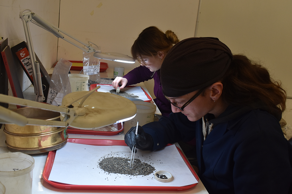
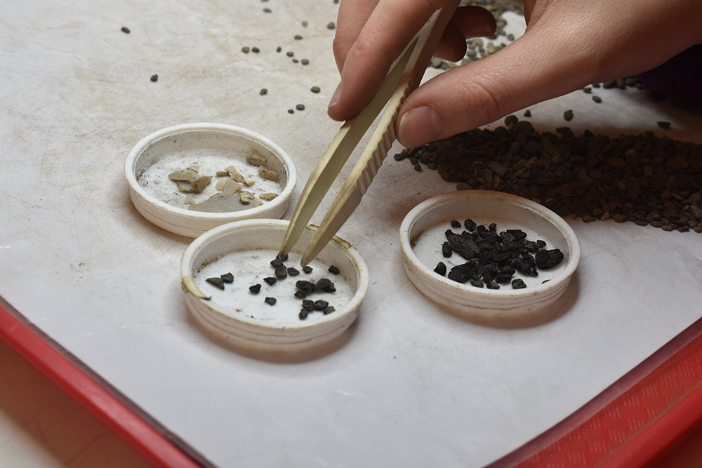
During the fieldwork investigations some 3,190 bulk soil samples were recovered from archaeological contexts. Processing and analysis of these samples will recover small artefacts as well as plant remains (charcoal, seeds, pollen, including insect remains and possibly land snails etc). Identification of the plant remains may provide information on the types of crops grown and the local vegetation history and environment. This analysis will also provide information on available organic resources for each period, as well as providing material suitable for radiocarbon dating. The work will also contribute to our understanding of how the wider climate and the local environment have changed over the past seven millennia.
Separation of the carbonised vegetation from the processed samples
In addition to the samples recovered from the individual archaeological contexts, a further 2472 samples were recovered as part of the artefact sampling strategy during the excavation of the Mesolithic site. Processing and analysis of these samples will contribute to the understanding of how the knapping site, for example, was used through time.