Author Archives: Admin

Uncovering an ancient face from Pictland

Share this page

facial reconstruction

In 1986, a long cist burial was uncovered at Bridge of Tilt near Blair Atholl in the Highlands. The cist contained the skeleton of a man who had died in his forties. Analyses of his bones suggested that he was used to hard work. The burial was dated to 340 –615 AD and is one of the earliest Pictish graves found so far.

GUARD Archaeology Ltd with support from Historic Environment Scotland are working with several local community groups including Blair Atholl Country Life Museum, Perth Museum and Art Gallery, the Clan Donnachaidh Society, the local Community Council and local primary school to undertake further investigations and analysis based on the burial. As part of this we have worked with a forensic artist Hayley Fisher to create a digital reconstruction of the man. This reconstruction as well as the skeleton is on display as part of ‘Picts and Pixels’ summer exhibition at Perth Museum and Art Gallery which opens on Saturday 20 May.

A sample from the skeleton is currently being assessed for DNA analysis and samples for isotope analysis will be taken to provide information on diet and where the man originated from.

In addition, GUARD Archaeology will be leading fieldwork in Blair Atholl over the weekend of 18 – 21 August 2017. GUARD Archaeologists will be on hand to offer guidance to volunteers on historical research, geophysical survey and trial trenching.

Anyone interested in taking part during the weekend of 18-21 August 2017 should contact Bob Will at GUARD Archaeology or simply turn up on the day.

Location of site

Location of site

Share this page

People, Plants, Medicine and Lore

Share this page

GUARD Archaeologists offering guidance to one of the volunteers during the previous community work at Bannockburn © Callum Bennets @ Maverick Photo Agency

GUARD Archaeology will be revisiting the battlefield of Bannockburn this year, assisting the National Trust for Scotland’s People, Plants, Medicine and Lore Project at the Bannockburn Battlefield Centre.

This exciting new community project, funded by the Heritage Lottery Fund, forms part of the 2017 celebrations for the “Year of History, Heritage and Archaeology” that explores how our relationship with the natural environment has changed over the last 700 years.

The project will work with local schools, community groups and the general public to put the Bannockburn landscape into context and discover how plants have been used down the generations. There will be practical opportunities to carry out experimental archaeology providing a greater understanding of how plants in the landscape would have been preserved.

A physic garden will also be created in the grounds of the visitor centre which will enable the local community to learn about the importance of cultivating medicinal herbs in the past. Local school pupils will explore the use of physic gardens through storytelling, art and literacy, as well as creating their own traditional remedies safely. They will share their knowledge with the wider community through guided tours and designing information panels. Visitors to the Battle of Bannockburn Visitor Centre will be able to explore the physic garden through observation, smell and touch and gain an appreciation of the knowledge needed by soldiers to survive in their natural environment.

GUARD Archaeologists will be on hand to offer guidance on the excavation of test pits and a metal-detecting survey, as well as a programme of school and volunteer training and activities.

Anyone interested in taking part during the weekend of 25-26 March 2017 should either contact Warren Bailie at GUARD Archaeology or simply turn up on the day.

Share this page

Discovery of Rare Bronze Age Weapon Hoard

Share this page

The Bronze Age Hoard as it was first revealed during excavations at Carnoustie © GUARD Archaeology Ltd

GUARD Archaeologists have recently recovered a very rare and internationally significant hoard of metalwork that is a major addition to Scottish Late Bronze Age archaeology.

A bronze spearhead decorated with gold was found alongside a bronze sword, pin and scabbard fittings in a pit close to a Bronze Age settlement excavated by a team of GUARD Archaeologists led by Alan Hunter Blair, on behalf of Angus Council in advance of their development of two football pitches at Carnoustie.

Each individual object in the hoard is significant but the presence of gold ornament on the spearhead makes this an exceptional group. Within Britain and Ireland, only a handful of such spearheads are known – among them a weapon hoard found in 1963 at Pyotdykes Farm to the west of Dundee. These two weapon hoards from Angus – found only a few kilometres apart – hint at the wealth of the local warrior society during the centuries around 1000-800 BC.

There are two more aspects that elevate the Carnoustie discovery to international significance. The first aspect is the extremely rare survival of organic remains. A leather and wooden scabbard encased the Carnoustie sword and is probably the best preserved Late Bronze Age sword scabbard ever found in Britain. Fur skin survives around the spearhead, and textile around the pin and scabbard. Such organic remains rarely survive on dryland sites.

The second aspect is that the hoard is not an isolated find but was buried within a Late Bronze Age settlement, which means that once the excavation has been completed it will be possible to study the archaeological context of the hoard, revealing new insights into the local Bronze Age community that buried it. Not least of which was the longevity of settlement here. For the excavation has also revealed the largest Neolithic hall so far found in Scotland, a building dating to around 4000 BC and that may have been as old to the people who buried the weapon hoard, as they are to us.

‘It is very unusual to recover such artefacts in a modern archaeological excavation, which can reveal so much about the context of its burial. Owing to the fragile nature of these remains when we first discovered them, our team removed the entire pit, and the surrounding subsoil which it was cut into, as a single 80 kg block of soil,’ said GUARD Project Officer Alan Hunter Blair. ‘This was then delivered to our Finds Lab where it was assessed by a specialist Finds Conservator to plan how it could be carefully excavated and the artefacts conserved.’

‘Organic evidence like Bronze Age wooden scabbards rarely survive so this just underlines how extraordinary these finds are,’ said GUARD Project Officer, Beth Spence, who undertook the excavation of the hoard in GUARD Archaeology’s Finds Lab along with Conservator Will Murray from the Scottish Conservation Studio.

Along with the hoard, the GUARD Archaeology team have discovered around 1000 archaeological features, among them the remains of up to 12 sub-circular houses that probably date to the Bronze Age along with the remains of 2 rectilinear halls that likely date to the Neolithic period. Some of the other archaeology on site consists of clusters of large pits containing discarded, broken pots and lithic artefacts. It is unclear yet if the archaeological remains comprise a settlement that lasted from the Neolithic until the Late Bronze Age or if it comprises several settlements built upon the same site but separated in time by many centuries.

Claire Herbert of ACAS, Archaeological advisers to Angus Council, said ‘The archaeology uncovered at Carnoustie is undoubtedly of national and international significance, and will certainly further enhance our knowledge of the prehistory of this area, providing an invaluable opportunity to learn more about how people in Angus lived in the Neolithic and Bronze Age.’

Angus Council communities convener Donald Morrison added: ‘It is clear that Carnoustie was as much a hive of activity in Neolithic and Bronze Age times as it is now. The discoveries made on land destined for sporting development have given us a fascinating insight into our Angus forebears and I look forward to learning more about our local prehistory.’

Vice convener Jeanette Gaul said: ‘To make such a find while preparing to create sports facilities for Carnoustie came as a huge surprise to us all. We’ve since learned it is of national and, indeed, international importance. But I am pleased that the archaeologists have involved local young people in the excavation project and are offering us all an insight into Angus’ distant past.’

In tandem with the excavation, GUARD Archaeology have brought community benefits and added value to the work by providing tours and presentations for local schools, including Carnoustie High School and Monifieth High School. Work experience for two students (from Carnoustie High School and Brechin High School) was also provided. Each of the students were trained in core skills in archaeology and were provided with a bespoke training plan and an archaeology skills passport for potential future careers in archaeology. In addition, GUARD Archaeology provided employment throughout the contract for a recently graduated archaeologist from Dundee. Throughout the project GUARD Archaeology have strived to use local suppliers and resources so that as much of the contract value as possible goes back into the local economy.

Share this page

Student Placements at GUARD Archaeology

Share this page

Rhiannon Lanosky MacFarlane (left) and Rebecca Loew (right) now working for GUARD Archaeology Ltd © GUARD Archaeology Ltd

As a Chartered Institute for Archaeologists Registered Organisation we not only take very seriously the training of our own staff, all of whose training needs are assessed via an annual skills audit, personal development plans and a continuing professional development log. But we also take very seriously the training of the next generation of archaeologists and our long-standing relationship with the Department of Archaeology at the University of Glasgow helps make this possible. Our training policy caters for early career archaeologists, volunteers and placement students entering the profession with limited experience and/or skills within the heritage sector (Pathway to PCIfA). Since 2011, we have taken on 9 student placements, several of whom have gone on to find employment with us and other archaeology companies.

‘It was the option of a work placement and research report as opposed to a dissertation that first brought me to the University of Glasgow’, said one of this year’s student placements, Rhiannon Lanosky MacFarlane. ‘I knew that as a student coming from another discipline I did not have the practical experience most others did when coming into the MLitt Material Culture and Artefacts Studies programme. In my seven week placement with GUARD Archaeology I was able to contribute to various ongoing projects acquiring a variety of skills – survey and field walking, evaluation, finds processing and cataloguing, flotation, and artefact illustration, all processes that are necessary when analysing a site. One project stayed with me, and I was fortunate enough that GUARD Archaeology allowed me to use it for my research report. While on placement I had begun cleaning the ceramic assemblage from GUARD Archaeology’s ongoing excavation of Partick Castle in Glasgow. From there I began illustrating the finds, through traditional and digital means. As I became familiar with the assemblage I wondered if it would be possible for me to reconstruct some of the pottery. With the skill sets I learned on placement I was able to build upon that knowledge, teaching myself photogrammetry and 3D animation. Combined with the luck of finding the sherds within the large assemblage, I was able to create a 3D reconstruction of a near complete medieval vessel from Partick Castle.’

‘While I am still learning, I feel this opportunity has given me much more than any classroom could’, added Rhiannon. ‘It gives the student the chance to choose how they learn, and what they want to focus on, whether it be commercial archaeology or in a museum. I came into the placement knowing the direction I wanted to pursue. I did it, and I thoroughly enjoyed it, but now there is so much more that I am interested in.’

Another student at the University of Glasgow’s Material Culture and Artefact Studies programme who took a placement at GUARD Archaeology this summer was Rebecca Loew. Originally from Wisconsin in the USA Rebecca was drawn to the programme precisely because there was an option to participate in a work placement. ‘The GUARD Archaeology staff were welcoming and willing to teach us about all of the different aspects of being an archaeologist’, said Rebecca. ‘The work varied from walkover surveys assessing how future developments might impact sites, to washing and cataloguing artefacts as part of the post-excavation process. We shadowed a member of staff as they went to schools to teach children about local archaeology and shadowed another member of staff during an evaluation, helping to record archaeology as it was being unearthed. I will forever be grateful to GUARD Archaeology for making this such an enjoyable experience and taking the time to teach me more about the profession that I am just starting out in.’

At the heart of GUARD Archaeology’s training policy is a recognition that our staff members and the next generation of archaeologists are central to our success and therefore our success is directly related to the level of investment we make in their futures.

Share this page

Excavation of a post-medieval inn at Wilkhouse, Sutherland

Share this page

Photograph from air of Wilkhouse. The inn is at the top left and consists of two linked buildings. It has a large enclosure around it, which runs off photograph and indeed under the 1870s railway line. There is a late 18th century dwelling and enclosure below this. The Kintradwell broch stands on the raised beach at the bottom.

GUARD Archaeology will soon be undertaking an excavation in partnership with Clyne Heritage Societyand the University of Glasgow at the site of an inn just north of Brora in Sutherland.

This excavation seeks to investigate the remains of the inn here, which was in operation in the eighteenth century, and is believed to have been subject to the Clearances in the early nineteenth century.

The inn was identified as being of interest by Dr Donald Adamson, Chairman of GUARD Archaeology and honorary research affiliate, during his fieldwork for his University of Glasgow PhD thesis ‘Commercialisation, Change and Continuity: An Archaeological Study of Rural Commercial Practice in the Scottish Highlands’. A similar excavation outside Strachur was carried out in 2014, and you can see the results of this at archaeology Reports Online (ARO 17: Tigh Caol) available at www.archaeologyreportsonline.com.

The excavation will be taking place over 2 weeks from Monday 22 May 2017 to Friday 2 June 2017.

The excavation will be directed by Warren Bailie of GUARD Archaeology, who directed the excavation at Strachur. Along with members of Clyne Heritage Society, many of whom have excavation experience through the society’s outstanding work at the sixteenth century salt works at Brora, archaeology students and local volunteers will be taking part.

There is one more available space for a student volunteer.

Any archaeology student interested in taking part should contact Warren Bailie by 28 February 2017.

Share this page

Metal Detecting in Scotland

Share this page

Metal detecting across the Killiecrankie Battlefield © GUARD Archaeology Ltd

A new report by GUARD Archaeology, undertaken on behalf of Treasure Trove Unit (TTU) and Historic Environment Scotland (HES), outlines extent of metal detecting in Scotland for the first time.

‘Collaborative metal detecting in Scotland’ is a project initiated and funded by TTU and HES. The TTU are the first port of call when detectorists uncover new material, and work to preserve significant historic objects for the benefit of the nation by providing a pathway for allocation to museum collections across Scotland. They also investigate and assess objects. The project encourages closer collaboration between Scotland’s metal detecting community and the heritage sector and has just published the first ever report to outline the extent and character of metal detecting in Scotland.

The TTU’s Dr Natasha Ferguson, who heads up the project, said, ‘The metal detecting community in Scotland finds and reports hundreds of objects every year to the Treasure Trove Unit – some of which are of national or even international importance. However, even with the best intentions some artefacts can be damaged, or sensitive archaeology disturbed. We want to ensure artefacts discovered through recreational activities like metal detecting are recovered carefully and a detailed find spot recorded so important archaeological information is not lost. The intention of the project is primarily to raise awareness of best practice when metal detecting, and to ensure the appropriate support and guidance is available to detectorists. The enthusiasm and expertise of the metal detecting community makes a significant contribution to Scotland’s heritage sector, and we want to help to maximise its potential. By working together we can create a system that ensures the best result for everyone.’

The report is the first of its kind to be attempted in Scotland. It was conducted by Warren Bailie of GUARD Archaeology, using online questionnaires and one-to-one interviews with detectorists and heritage professionals to find out the extent of metal detecting in Scotland, the different ways it takes place across the country, as well as to ask those involved for their views on how the process of find reporting works. Warren has worked with volunteer metal detectorists on numerous sites over the last few years including the battlefield of Bannockburn and Killiecrankie.

The report found that there are approximately 521 ‘hobbyist’ metal detectorists in Scotland, 87% of whom are male, with a predominant age range between 45 and 55 years old. The areas with the highest recorded activity of metal detecting in Scotland were Perth and Kinross, Fife, Dumfries and Galloway, and the Scottish Borders.

Kevin Munro, Senior Designations Officer for Historic Environment Scotland, said: ‘Anecdotally, we seem to be seeing an increase in the numbers of people participating in metal detecting in Scotland – perhaps due to a number of high profile finds by detectorists in Britain in the past decade. We know that detectorists have a great interest in history, and we hope that the project will help us to ensure that they are aware of the appropriate processes for reporting finds when they are discovered. The report also highlighted that there are some issues of trust between detectorists and heritage professionals, and occasionally a mutual misunderstanding of either groups’ aims. Identifying these challenges is the first step towards tackling them, and generating a positive environment for working together in a constructive, collaborative manner. So the aim of the project is to bring these groups together in order to generate closer collaboration, to iron out the current underlying issues, and to try to improve and encourage best practice. It’s very encouraging to see that there is an appetite amongst all parties to improve engagement and to increase collaboration – which can only be to the benefit of our understanding of Scotland’s past in the long run.’

Other findings from the report were that only 55.4% of detectorists use GPS devices to accurately record find-spots, that the average length of participation in the hobby is nine years, and that metal detecting group outings are a preferred means of pursuing the hobby – with an average of between 20 and 40 attendees at each organised ‘dig’.

The report Assessment of the Extent and Character of Hobbyist Metal Detecting in Scotlandis available for download on the Historic Environment Scotland publications page.

Share this page

Discovery of Lost Dark Age Kingdom In Galloway

Share this page

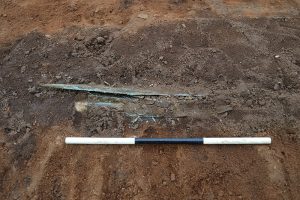
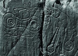
A laser scan image of the Pictish symbols carved at Trusty’s Hill, comprising a z-rod-and-double-disc symbol on the left and a dragon-pierced-by-a-sword symbol on the right © DGNHAS / CDDV

Archaeological research led by GUARD Archaeology has just been published which reveals the location of a hitherto lost early medieval kingdom that was once pre-eminent in Scotland and Northern England.

The kingdom of Rheged is probably the most elusive of all the sixth century kingdoms of Dark Age Britain. Despite contributing a rich source of some of the earliest medieval poetry to be composed in Britain – the poetry of Taliesin who extolled the prowess of its king, Urien of Rheged – and fragments of early medieval historical records of Urien’s dominance in southern Scotland and northern England, the actual location of Rheged has long been shrouded in mystery.

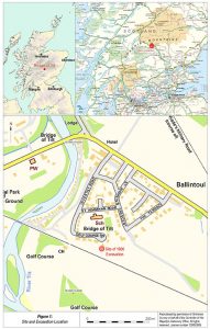
While many historians have assumed it was centred around Carlisle and Cumbria, no evidence has ever been found to back this up. However, new archaeological evidence from the excavation of Trusty’s Hill Fort at Gatehouse of Fleet in Dumfries and Galloway now challenges this assumption.

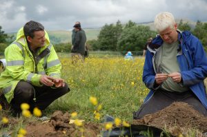
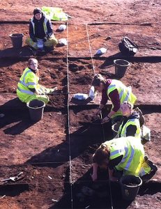
‘What drew us to Trusty’s Hill were Pictish symbols carved on to bedrock here, which are unique in this region and far to the south of where Pictish carvings are normally found,’ said Ronan Toolis of GUARD Archaeology, who led the excavation which involved the participation of over 60 volunteers. ‘The Galloway Picts Project was launched in 2012 to recover evidence for the archaeological context of these carvings but far from validating the existence of ‘Galloway Picts’, the archaeological context revealed by our excavation instead suggests the carvings relate to a royal stronghold and place of inauguration for the local Britons of Galloway around AD 600. Examined in the context of contemporary sites across Scotland and northern England, the archaeological evidence suggests that Galloway may have been the heart of the lost Dark Age kingdom of Rheged, a kingdom that was in the late sixth century pre-eminent amongst the kingdoms of the north.’

The excavation revealed in the decades around AD 600, the summit of the hill was fortified with a timber-laced stone rampart. Around the same time supplementary defences and enclosures were added to its lower-lying slopes transforming Trusty’s Hill into a nucleated fort, a type of fort in Scotland that has been recognised by archaeologists as high status settlements of the early medieval period.

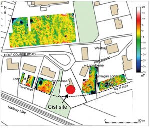
Anyone approaching the summit of Trusty’s Hill passed between a rock-cut basin on one flank and an outcrop on which two Pictish symbols were carved on the other. This formed a symbolic entranceway, a literal rite of passage, where rituals of royal inauguration were conducted. On entering the summit citadel one may have been greeted with the sight of the king’s hall at the highest part of the hill on the west side, where feasting took place, and the workshop of his master smith occupying a slightly lower area on the eastern side, where gold, silver, bronze and iron were worked into objects. The layout of this fort was complex, each element deliberately formed to exhibit the power and status of its household.

The excavation also found the remains of a workshop that was producing high status metalwork of gold, silver, bronze and iron. The royal household here was also part of a trade network that linked western Britain with Ireland and Continental Europe. In fact, research now shows that over the late sixth and early seventh centuries AD Gaulish merchants were making a beeline for the Galloway coast, ignoring Cumbria entirely. The excavation revealed that one of the reasons for this may have been to acquire materials like copper and lead. Isotope analysis of a lead ingot found during the excavation of Trusty’s Hill was found to have originated in the Leadhills of south-west Scotland, demonstrating that this mineral source was being mined and used to make leaded bronze objects at this time.

Other activities apparent at Trusty’s Hill included the spinning of wool, preparation of leather and feasting. The diet of this early medieval household, with the predominant consumption of cattle over sheep and pigs, and oats and barley rather than wheat, was largely indistinguishable from their Iron Age ancestors.

‘The people living at Trusty’s Hill were not engaged in agriculture themselves,’ said excavation co-director Dr Christopher Bowles, Scottish Borders Council Archaeologist. ‘Instead, this household’s wealth relied on their control of farming, animal husbandry and the management of local natural resources – minerals and timber – from an estate probably spanning the wider landscape of the Fleet valley and estuary. Control was maintained by bonding the people of this land and the districts beyond to the royal household, by gifts, promises of protection and the bounties of raiding and warfare.’

It is in this context that the Pictish symbols at Trusty’s Hill can now be viewed. The new analysis of the symbols here leave no doubt that the symbols are genuine early medieval carvings, likely created by a local Briton, melding innovation, contacts with Atlantic Europe and deep seated traditions.

‘The literal meaning of the symbols at Trusty’s Hill will probably never be known. There is no Pictish Rosetta Stone,’ said Ronan Toolis. ‘But they provide significant evidence for the initial cross cultural exchanges that forged the notion of kingship in early medieval Scotland.’

The location of the symbols at the entranceway to the summit of Trusty’s Hill and opposite a rock-cut basin, mirrors the context of the inauguration stone at Dunadd, the royal centre for the kings of Dalriada, the early Scots kingdom that once covered what is now Argyll and Bute. The imported goods and production of fine metalwork at Trusty’s Hill is comparable in quality to Dunadd, showing that these two royal households were of equal status. Dunadd’s Pictish boar, footprint, ogham and rock-cut basin at the entrance to the summit enclosure are best viewed as a set of royal regalia where the rituals of inauguration took place. The only other Pictish carvings located outside Pictland were found near Edinburgh Castle Rock; another site attested by archaeological and historical evidence to be a royal stronghold of the sixth to early seventh centuries AD. Close comparisons can also now be drawn with the early sixth century royal site at Rhynie in the heart of what was once Pictland.

The 2012 excavation at Trusty’s Hill sought to reveal the archaeological context for the Pictish style carvings. They succeeded in showing that the site was very likely a royal stronghold and place of inauguration of the local Britons of Galloway.

A cluster of contemporary Dark Age sites, such as Whithorn, Kirkmadrine and the Mote of Mark, is now known in Galloway. Trusty’s Hill is the only one of these where there is evidence of royal inauguration and suggests that this site was at the apex of a local social hierarchy. The new evidence from Trusty’s Hill now provides a political context to the wealth and complexity of Galloway during the sixth century, the attraction of the region to continental merchants, and Galloway’s claim as the cradle of Christianity in Scotland. The archaeological record for the establishment of Christianity in southern Scotland suggests that its elite communities were literate and well connected internationally. This could not have occurred without a powerful secular presence providing land and resources. With the corroboration of the literary, historical and archaeological evidence, we begin to see the tantalising clues to a vibrant and dynamic culture that is entirely consistent with Rheged, a kingdom that was pre-eminent in northern Britain in the later sixth century but which faded into obscurity through the course of the seventh century. The deliberate and spectacular destruction of Trusty’s Hill and the nearby contemporary fort at the Mote of Mark in the seventh century AD, which can also be surmised for a number of similar forts in Galloway, is a visceral reminder that the demise of this kingdom in the early seventh century AD came with sword and flame.

‘The new archaeological evidence from Trusty’s Hill enhances our perception of power, politics, economy and culture at a time when the foundations for the kingdoms of Scotland, England and Wales were being laid,’ said Dr Bowles. ‘The 2012 excavations show that Trusty’s Hill was likely the royal seat of Rheged, a kingdom that had Galloway as its heartland. This was a place of religious, cultural and political innovation whose contribution to culture in Scotland has perhaps not been given due recognition. Yet the influence of Rheged, with Trusty’s Hill at its secular heart, Whithorn as its religious centre, Taliesin its poetic master and Urien its most famous king, has nevertheless rippled through the history and literature of Scotland and beyond.’

The Lost Dark Age Kingdom of Rheged by Ronan Toolis and Christopher Bowles is published by Oxbow Books.

The book launch of The Lost Dark Age Kingdom of Rheged is taking place at 2-4pm on Saturday 21 January 2017 at the Murray Arms Hotel, Gatehouse of Fleet.

For more information about the Galloway Picts Project, visit the Galloway Picts website.

The Galloway Picts Project was supported by the Dumfriesshire and Galloway Natural History and Antiquarian Society, the Heritage Lottery Fund, the Society of Antiquaries of Scotland, GUARD Archaeology Ltd, the Mouswald Trust, the Hunter Archaeological & Historical Trust, the Strathmartine Trust, the Gatehouse Development Initiative, the John Younger Trust, the Galloway Preservation Society and Historic Environment Scotland.

Share this page

Ben Lawers: An Archaeological Landscape in Time

Share this page

Location Map defining the project area and key sites © GUARD Archaeology Ltd

Research by GUARD Archaeology has just been published, presenting the results of the Ben Lawers Historic Landscape Project, a multi-disciplinary project carried out between 1996 and 2005 in the Central Highlands of Scotland.
The Ben Lawers Project had wide-ranging aims based around developing a project that would enable a greater understanding of the last thousand years of human history across an area of upland landscape on the north side of Loch Tay. It became apparent from the very first excavation season that the laudable goal of restricting the project to the second millennium AD would be almost impossible to achieve. The very nature of the landscape which formed the study area, with its limited flat agricultural land and steep slopes stretching towards the massive peaks of Tarmachan, Lawers, Ghlas, An Stuc and Meall Greigh, would conspire to defeat any such policy. The combined factors of topography, hydrology and geology encouraged the use of particular points in the landscape through time.

Locations that were suitable for early inhabitants to hunt, build houses or bury their dead would also be the best for future generations to use in similar ways. The project, throughout its nine years of existence, revealed evidence for this palimpsest of activity on a regular basis. The chronological depth of activity exposed during the project thus allowed the processes of change, expansion and retraction of settlement to be understood within a longer timeline of human occupation.

By the end of the 2nd century AD, abandonment of hut-circles, homesteads and crannogs on Loch Tay had occurred, and the project found no archaeological trace of human occupation during the next 250 years. The re-occupation of Eilean Breaban Crannog sometime after AD 420 was followed by a sequence of other occupation events, such as isolated, ephemeral features sealed under later buildings at Kiltyrie. Excavation at Balnahanaid revealed more structured evidence in the form of long cists and graves, which were contemporary with the early phase of occupation of Kiltyrie, and for the first time allowed the sample excavation of an annat site in Scotland. Annat or annaid sites have attracted little detailed study in archaeological terms and probably represent church-sites. The cemetery at Balnahanaid certainly provides a tantalising view of the period and hints at the working of silver, possibly in crucibles, a craft that might be associated with a church of some standing. Whatever its import, Balnahanaid was abandoned sometime after AD 780, although the reason is unclear.

From the mid 12th century, a prolonged phase of occupation becomes apparent within the landscapes of Lawers. It began with the reoccupation of Kiltyrie, which lasted until AD 1300 if not as late as the mid 15th century. The re-occupation of marginal fringes for agriculture is characteristic of the expansions in settlement-pattern associated with better weather conditions during the Medieval Optimum. This phase of expansion is evident in other upland areas of Britain, particularly the Scottish Borders, north-west England, Wales and more generally across north-west Europe. The Ben Lawers sites offer a glimpse of settlement forms during the Medieval Optimum, especially between AD 1150 and 1300. These find comparisons elsewhere in Perthshire and bear similarities in layout to contemporary sites excavated in the Western Isles. Towards the end of the 13th century, the climate began to change and it is likely that the colder and wetter conditions led to a retraction of permanent settlement from higher elevations in Perthshire, as it did elsewhere in Europe. The evidence from Ben Lawers suggests that this occurred in the decades immediately prior to 1300, but some use of sites may have continued into the 14th or possibly even the 15th centuries. What form this use took is less than clear, but it may have been seasonal.

Seasonal exploitation of the upland zone on Loch Tayside was certainly apparent from evidence recovered at shieling-sites investigated during the project. Whether transhumance was practised before this on Loch Tay is not clear from the physical or documentary evidence, although the term ‘shieling’ first appears in documents of the late 12th century in the Highlands. The archaeological evidence indicates that sites such as Meall Greigh may have been used on a seasonal basis from c 1400 until the late 18th century. This is supported by entries in the Breadalbane papers from the late 16th century onwards. For much of this period these documents, together with the excavation results, provide the only evidence for the later medieval and early post-medieval occupation of Loch Tay.

The excavation results also provide an interesting contrast with the published body of work on transhumance sites. Much of the work published to date relates to the Western Isles. The data produced as part of the Ben Lawers Project therefore offers the first comparative material for the whole of the highland massif. It also provides tangible evidence for the function and chronology of a range of structural forms, from the small, sub-circular or oval turf bothies to the elongated, sub-rectangular huts with their central entrances and stone-lined, turf-battered walls. The evidence from Ben Lawers indicates that both forms were concurrent features of the landscape, and the differences between them may reflect social forces at work in the pastoral zone. The evidence also highlights these structures’ lack of permanence, from the makeshift roofing arrangements to the lack of material culture and even, in some cases, the apparent absence of hearths. In dating terms the evidence suggests that the tradition was certainly active in the 16th and 17th centuries and probably came to an end towards the end of the 18th century, although occasional use may have extended beyond this.

By the beginning of the 18th century changes in construction materials and the detailed and meticulous record-keeping of the Breadalbane estate enabled the project once again to find evidence for the lives of the common people across the arable zone on Loch Tayside. Farquharson’s map of 1769 is particularly characteristic of this capturing of detail. The settlement-distribution mapped by Farquharson provides a snapshot of the form and layout of the pre-Improvement landscape prior to the wholesale changes initiated by the General Lease c 1800 and the abandonment of the infield/outfield system of agriculture. Ironically, although we can differentiate the locations of up to 65 18th-century settlement-sites from the sites occupied during the 19th century, it is not so easy to disentangle the archaeology of the physical remains and relate this to an underlying chronology. There is a clear lack of datable material for 18th-century occupation horizons. This, combined with the later occupation of sites (post-1769) and the wholesale remodelling of some settlements has created a complex mixture of 18th- and 19th-century cultural traits. In most cases this later occupation has obscured any trace of 18th-century use. This was certainly the case for many of the sites investigated as part of this project. Even in cases like Balnasuim, the later use of the site and subsequent robbing of stone left few traces of the building’s use during the 1700s.

In contrast, the expansion of the settlement pattern into the former outfield areas after the introduction of the General Lease in 1800 provides an entirely different body of evidence. These outfield sites were generally of a single phase, used for little more than a generation and accompanied by datable material culture. Sites like Kiltyrie provide a unique if fleeting view of early 19th century life in the Highlands, and some can even be related to particular individuals. The analysis of the ceramic and glass assemblages from these sites has permitted a clearer understanding of how people lived, what vessels they owned and when such objects became an essential part of everyday life. Contrasting these assemblages with material from other sites, such as Balnabodach on Barra and Easter Raitts in Badenoch has begun to address issues of trade and commerce over large distances and the role of peddlers and travellers in this process. By the 1820s the occupants of most of the outfield sites were beginning to struggle; the system on which the estate had placed such high hopes was failing. The evidence from the excavations supports the supposition that failure accelerated during the 1830s and the new system had all but collapsed by the middle of the century. The shrinking of the settlement-pattern and decline in arable production were inevitably matched by an inexorable fall in population throughout the rest of the 19th and into the 20th century. The remnant historic landscapes we see today along the north shores of the loch are testament to that demographic change.

‘Ben Lawers: An Archaeological Landscape in Time. Results from the Ben Lawers Historic Landscape Project, 1996–2005’ by John Atkinson has recently been published by the Society of Antiquaries of Scotland as Scottish Archaeological Internet Report 62

Share this page