Category Archives: 2018 News

Mote of Urr published after 65 years

Share this page

ARO31 Cover

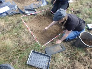
The results of Brian Hope-Taylor’s excavation of the Mote of Urr, undertaken 65 years ago, have now been published in GUARD Archaeology’s publications journal ARO. Excavations at Mote of Urr, near Dalbeattie in Dumfries and Galloway were undertaken in 1951 and 1953. The earliest phase of occupation comprised the construction of the motte-and-bailey castle and its destruction by fire, after which a large central stone-lined pit for an oven, furnace, kiln or beacon was dug. The pit continued in use when the motte was heightened and enclosed by a clay bank and palisade during a second phase of occupation. In its final phase, when the motte was heightened again, a possible double palisade enclosing the summit of the motte was found.


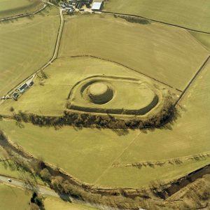
Mote of Urr © Historic Environment Scotland


Hope-Taylor dated the construction and earliest occupation at Mote of Urr to the late twelfth century, with continued occupation into the fourteenth century. Although Mote of Urr seems to have been the centre for Walter de Berkeley’s lordship of Urr in the second half of the twelfth century, nothing as early as this was identified in the pottery and artefacts recovered from the excavations. Only two radiocarbon dates from the earliest phase of occupation support the twelfth-century occupation at the motte, which probably terminated during the rebellion in Galloway in 1174. A radiocarbon date of AD 1215-1285 from a later pit suggests that the heightening and strengthening of the motte took place in the thirteenth century. Pottery evidence suggests occupation in the thirteenth century, continuing into the second half of the fourteenth century, if not into the fifteenth century.

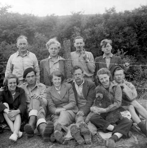
The Mote of Urr excavation team. Brian Hope-Taylor is in the back row, second from the left © Historic Environment Scotland

‘Brian Hope-Taylor was a charismatic and perspicacious scholar, though like some other archaeologists he did not find it easy to write up the results of his excavations for final publication,’ said Professor Barbara Crawford of the University of St Andrews and University of the Highlands and Islands. ‘It is therefore with appreciation of Brian Hope-Taylor’s skills as a teacher and more particularly as an excavator of important medieval sites in northern England and southern Scotland that I welcome this publication. It will advance our understanding of these impressive mounds in the landscape and perpetuate Hope-Taylor’s legacy in exploring such lordship sites.’

The full results of this research, which was funded by Historic Environment Scotland, ARO31: Brian Hope-Taylor’s archaeological legacy: Excavations at Mote of Urr, 1951 and 1953 by David Perry with contributions by Simon Chenery, Derek Hall, Mhairi Hastie, Davie Mason, Richard D Oram, and Catherine Smith is freely available to download from the ARO website – Archaeology Reports Online.

Share this page

Roman roadside settlement revealed beneath Kirkby Thore, Cumbria

Share this page

GUARD Archaeologists revealing archaeological features at Kirkby Thore © GUARD Archaeology Ltd

A team of GUARD Archaeologists have discovered the remains of a Roman vicus settlement just outside the Roman Fort of Bravoniacum.

The team from GUARD Archaeology Ltd were working with Highways England and Amey Consulting during improvement works to the A66 at Kirkby Thore in Cumbria. To minimise disruption to traffic along the A66, the work was undertaken at weekends and overnight.

The route of the modern A66 roughly follows an important Roman road which linked the Roman forts and settlements of Cumbria with the Roman forts and settlements of North Yorkshire, passing through the vicus (or village) that lay just outside the Roman fort of Bravoniacum, which lies below modern-day Kirkby Thore.

‘Not only have we revealed the foundations of the Roman road,’ said GUARD excavation director John-James Atkinson, ‘but we have revealed traces of timber buildings that lay adjacent, to the south-west of the fort. While the timber has long since rotted away, the construction of these buildings has left post-holes and pits from which we have recovered a variety of Roman pottery sherds.’

The Roman pottery sherds include Samian pottery from Roman Gaul which was once used as fine tableware for rich and well-connected soldiers and citizens, amphorae which may have once held wine or olive oil from the Mediterranean as well as more common greyware and coarse ware that was made in Roman Britain itself.

‘The pottery dates from the first to the fourth century AD,’ added John-James Atkinson, ‘which neatly ties in with the known occupation of the fort.’

The GUARD Archaeologists also encountered a grave burial. While this was left unexcavated, to be preserved in situ, its exact location was surveyed in and samples taken so that it can be dated.

The Roman fort of Bravoniacum was once garrisoned by a squadron of Syrian archers. This unit of the Roman army was in the fourth century AD under the overall command of the Duke of the Britains, who from his base in York was responsible for keeping the northern frontier secure and the citizens of the four provinces within Late Roman Britain safe from Pictish raids. So the importance of keeping the road open and accessible was as important then as it is now.

Share this page

Uncovering the house of the Blackfriars in Stirling

Share this page


ARO30

Investigations on the outskirts of medieval Stirling discovered the foundations of the medieval Dominican friary.

The archaeological excavation was carried out by GUARD Archaeology Ltd in 2014 in advance of re-development of land at Goosecroft Road by Cromwell Property Group (formerly Valad Europe) on behalf of the Stirling Development Agency. The foundations of substantial medieval stone walls and finely carved architectural fragments were revealed, belonging to the friary known to have occupied this area of the medieval burgh. Historical research reveals that this friary belonged to the Dominican Order – the Blackfriars – for over three hundred years, from 1233 to the Scottish Reformation in 1559.

Remains of skeleton during excavation

The archaeological finds included what remained of the skeleton of a young man. ‘He had been carefully buried in accordance with medieval Christian burial rites within the precincts of the friary,’ explained Maureen Kilpatrick, who analysed the human remains. ‘He was placed on his back in an extended position and orientated east/west, with the head at the west end and the lower arms placed towards the pelvis. No skeletal pathology was noted on the skeleton, although the remains were very fragmentary, and any trace of disease may have been lost.’

The burial is consistent with other known medieval burials with regards to burial orientation and the positioning of the lower arms towards the pelvis, such as those found at other friary sites in Scotland at Aberdeen, Linlithgow and Perth. The arms placed across the body, whether across the chest or pelvis, have been interpreted as evidence of a body being firmly wrapped in a shroud and with the absence of any evidence for a coffin is more than likely the mode of burial of this individual. The location of the burial within the foundation trench of a wall is more unusual, although a similar burial of a young adult male buried within the south foundation wall of the nave was also discovered at the Carmelite friary in Linlithgow.

Bronze belt buckle found during excavation

While excavations at other medieval friary sites in Scotland have revealed burials of men, women and children suggesting the local populace was interred in friary grounds, the archaeological evidence suggests that this young man was a friar himself, which is usually quite difficult to demonstrate. However, as friars were buried in their habits, buckles found near the pelvis indicate those individuals being friars of orders such as the Dominicans, as their rule required them to wear a belt with a buckle, rather than a rope cincture worn by other orders such as the Franciscans (the Greyfriars). The finding of a 13th/14th century bronze belt buckle in front of the pelvic area of this individual and traces of mineralised textile on the inner edge indicating it was fastened against clothes therefore suggests that he was a friar rather than simply a local individual. Furthermore, his skeleton was radiocarbon dated to AD 1271 – 1320 so it is possible that this friar was a witness to some of the most significant events of the Scottish Wars of Independence during late 13th and early 14th centuries, not least the battles of Stirling Bridge and Bannockburn.

‘The approximately 326-year existence of the friary gleaned from historical records is now corroborated by the new archaeological evidence,’ said Bob Will who led the excavation. ‘Pottery sherds dating to this period derive from cooking vessels and jugs from different British regions as well as Continental Europe. The Blackfriars of Stirling had access to luxury table goods from around the North Sea, foodstuffs such as figs and raisins and wine. The friary as well as the burgh of Stirling was well positioned to receive imports, which may have been brought to land at Cambuskenneth Abbey which lies on the River Forth and was then navigable from the sea.’

GUARD Archaeologists excavating the medieval friary

One of the walls discovered during the excavation was likely to be a boundary wall for the friary that was replaced or reinforced by another with a drain, the latter possibly related to a lavatorium or kitchen. Two window glass shards and two window tracery fragments hint at the possibilities of a leaded glass window in an ecclesiastical building dating to the late fourteenth century. However, due to subsequent development of this area of Stirling, not least the robbing of stone from the friary after its dissolution, only part of the layout of the friary is known.

The full results of this research, which was funded by the Stirling Development Agency, ARO30: Uncovering the history and archaeology of the house of the Blackfriars, at Goosecroft Road, Stirling by Bob Will is freely available to download from the ARO website – Archaeology Reports Online.

Share this page

Digging Linlithgow’s medieval past

Share this page


Digging an archaeological test pit

Buried beneath the back gardens of Linlithgow High Street may be objects or archaeological remains from Linlithgow’s medieval past. A new plan is underway to find out more about this hidden heritage, part of an overall project funded and supported by the Heritage Lottery Fund, LEADER and West Lothian Council. Volunteers will soon be participating in this investigation, playing an important part in digging up their town’s history.


Digging will take place, over the weekend of 14–16th September 2018. The test pits will measure 1 m by 1 m and will be in selected back gardens of Linlithgow’s High Street. The work will be supervised by experienced archaeologists from GUARD Archaeology, who will guide and train each volunteer in hand excavation, finds discovery and identification, recording of discoveries and dating of artefacts.

Linlithgow from the air

The medieval burgh of Linlithgow is first recorded in the reign of David I (1124-53), when the king granted the ‘church of Linlidcu with chapels and lands inside the burgh and outside, and all rights pertaining to the foresaid church’ to St Andrews Cathedral in 1140 or 1141.

‘The burgh was a long single street, the High Street, forming part of the route westwards from Edinburgh to Stirling and Glasgow, with a shorter arm, Kirkgate, leading northwards to the royal palace and the parish church,’ said Iraia Arabaolaza from GUARD Archaeology. ‘This is an exciting way to find out more about Linlithgow’s history from the core of its medieval town.’

‘We are really excited to be working with GUARD Archaeology to find out what is underneath the streets of Linlithgow,’ added Stuart Kennedy from Linlithgow Heritage Trust. ‘This project is an important part of the lead up to the Museum reopening in 2019 and becoming a real community focused space.’

the project is funded by the organisations above

Share this page

A landscape of change on the outskirts of Edinburgh

Share this page

Archaeological investigations coupled with historical research of Newcraighall on the south-east edge of Edinburgh reveal a complex story of land use changes from prehistory to the present day.

Between 2011 and 2016, GUARD Archaeology teams led by Alan Hunter Blair undertook a series of surveys and excavations across land that had previously been part of the policies of Brunstane House and and Newhailes House. While the earliest activity encountered comprised groups of pits dating to the late Mesolithic/early Neolithic, late Neolithic and Bronze Age, the majority of features dated from the medieval and post-medieval periods through to modern times.

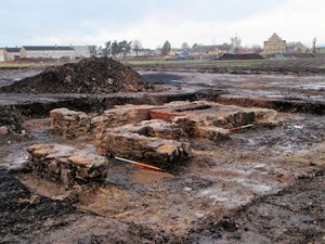
These included various sized coal pits or shafts, and the foundations of four colliery buildings, arranged around a now infilled mineshaft on the southern site. Elements of a designed landscape associated with Brunstane House included a ha-ha that traversed the northern site. The presence of several large culverts may also have connections with both landscape alterations and the coal-mining industry. Fragments of curved and linear ditches appear to be remnants of earlier field systems dating from the medieval and post-medieval periods and associated with extensive remnants of broad rig cultivation found across the two areas.

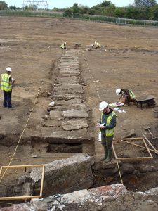
The historical research demonstrates the complexities of landownership with evidence of the development of coal mining and coal ownership and the social and economic realities of the times. Examination of papers relating to Brunstane House showed that they had direct bearing on the understanding and dating of the landscaping features and other groundworks, including changes to the estate boundaries and the runrig system. A labourer’s diary from the winter of 1735-6 was an especially interesting find from the point of view of what work was undertaken on the estate, by whom and for how much.

This project shows the value of combining two subject areas together, from their partial bodies of evidence, to produce a much more rounded view of the life of the times from the landowner to the coal miner during the post-medieval and early modern periods.

The full results of this research, which was funded by Barratt & David Wilson Homes East Scotland and Avant Homes, ARO29: Newcraighall, Edinburgh: A landscape of change through its archaeology and history by Alan Hunter Blair and Morag Cross is freely available to download from the ARO website – Archaeology Reports Online.

Share this page

Coastal storms and prehistoric hardship on North Uist

Share this page

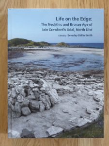
Newly published archaeological research from excavations undertaken at the Udal in North Uist reveals some of the hardships of life in Neolithic and early Bronze Age Scotland. Two burial cairns held the remains of individuals dating to the second millennium BC. Scientific analyses of these individuals demonstrate the dramatic effect that environmental stresses had on the community.

Excavations at the Udal revealed the archaeological remains of two round buildings dating to between 3000 and 2500 BC. Analysis of the artefacts indicates that butchering of animals, pottery-making and quartz tool manufacture took place here.

‘The two houses may have been the last surviving structures of a larger settlement that was covered over by a thick layer of blown sand, like Skara Brae on Orkney,’ said Beverley Ballin Smith of GUARD Archaeology, who has been leading the post-excavation work. ‘The storm that brought the sand covered fields and grazing lands in addition to the village, from dunes to the west. The effects were so severe that the buildings and the farming land had to be abandoned and people moved inland. How long it took the sand to consolidate before it could be used for grazing and agriculture is not known, but marks from an ard plough showed that fields had extended much further west and north than the coastline does today.’

The blown sand was only part of the environmental story as another severe storm later brought a flood that destroyed the new fields by depositing a thick stone and shingle beach across them. By this time the coastal landscape was in flux and was in the process of being dramatically transformed. The archaeological evidence reveals that these environmental hardships had a severe effect on the health of local inhabitants. Scientific analysis of the teeth of two skeletons buried on the site indicated they had suffered a lack of food as children, even periods of starvation, and shell fish such as whelks may have become a staple food stuff.

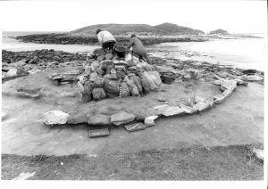
The accumulation of sand and the flooding episode separated the end of the late Neolithic settlement from the beginning of the early Bronze Age, around 2400 BC. Sometime after the creation of the beach, a burial cairn was built, under which a young man was laid to rest in stone cist. This large round mound of stone and turf was the largest man-made structure on the Udal peninsula. By erecting the cairn, the inhabitants that lived in the area claimed back the landscape as theirs. The monument was meant to be enduring and it lasted approximately 4000 years before coastal erosion threatened it, necessitating its excavation.

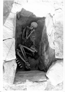
‘Our Neolithic and Bronze Age ancestors lived through climate change events such as dramatic sea-level rise and increased storminess, and trauma such as loss of fields, crops and animals. They had to relocate their settlement and houses to safer areas,’ said Beverley. ‘How the inhabitants of the Udal survived during the Bronze Age will be part of the research on the next Udal site – the South mound.’

The Udal is a peninsula off the north coast of North Uist and was the focus of many years of archaeological excavations by the late Iain Crawford. This book is the result of several years of post-excavation work on the smallest of the Udal sites, which was exposed by coastal erosion after an exceptional high tide in 1974. While Iain Crawford completed the fieldwork by 1984 he could not complete the project to publication. After a long illness he died in 2016 at the age of 88. The new book is edited by Beverley Ballin Smith, Publications Manager at GUARD Archaeology, who has spent the last few years analysing the archaeological material recovered from Iain’s excavations.

‘While the archaeology of the Western Isles is as rich, diverse and intriguing as that of the rest of Scotland, it is less well known,’ said Malcolm Burr, Chief Executive of Comhairle nan Eilean Siar. ‘Comhairle nan Eilean Siar and its partners are working hard to see this position change, and this new publication of the smallest of Iain Crawford’s excavations at the Udal site in North Uist, is part of this effort. The excavations at the Udal recovered fragile evidence in the face of erosion by sea, storm and the ravages of time. The story told by these structures and artefacts, however, reflects the earliest centuries of communities’ life experiences on the Udal headland from some six thousand years ago, one of the longest and most fascinating time lines in the archaeology of Scotland. The two Neolithic houses and Bronze Age burial cairn bear testimony to the antiquity and importance of this site.’

Dr Lisa Brown from Historic Environment Scotland said ‘It is great to see these results of the excavation of the Neolithic and Bronze Age remains now published, both as a book and free to download online. Using the most up to date scientific techniques, the author and contributors have been able to provide additional insight into how the earliest communities were living on this peninsular, and how they coped with the changes in the environment which affected their lives. We are pleased to have been able to support this work through our archaeology funding programme.’

This first major publication from the Udal project was launched at Sollas Community Hall in North Uist and was jointly funded by Historic Environment Scotland and Comhairle nan Eilean Siar.

The new hardback book, Life on the Edge: The Neolithic and Bronze Age of Iain Crawford’s Udal, North Uist edited by Beverley Ballin Smith is available from Archaeopress Publishing Ltd, at www.archaeopress.com for £25. A free version is also available to download from the same internet address.

Share this page

Search for lost Jacobite army camp at Bannockburn House

Share this page

Bannockburn House ©Bannockburn House Trust, 2018 – kindly donated by Alistair Thomson

The first survey of a potential site for the Jacobite army camp shortly before the battle of Falkirk is planned for the weekend of 3rd-5th August 2018.

In the summer of 1745, Prince Charles Edward Stuart, commonly known as Bonnie Prince Charlie, arrived in Scotland to raise an army and march towards England to reclaim the throne. On his way south, Charles spent the night of the 14th of September at Bannockburn House near Stirling.

It seems likely that there was a reason that Charles stayed at Bannockburn; perhaps the army command or the Prince himself was aware of the support of the house’s owner Hugh Paterson to the Jacobite cause, or perhaps he had met him in exile in the years after the 1715 rising. It is also possible that the selection of Bannockburn was solely for its practical location, near the road to Edinburgh.

In early January 1746, Charles returned to Bannockburn House following the retreat of the Jacobite army from England. Located so close to Stirling, this mansion made for ideal headquarters for the prince and his staff to prepare for the siege of Stirling.

Even though the city surrendered on January 8th 1746, the attempts of the Jacobite army to take Stirling Castle were unsuccessful. Meanwhile, the Hanoverian army, tasked with bringing the Jacobite army to battle, marched from Edinburgh to Falkirk, planning to advance on Stirling.

Contemporary drawing of Jacobite and Hanoverian soldiers from the Penicuik Collection

The Jacobite army set out to meet the Government forces. Although the ensuing battle on 17th January was a victory for the Jacobites, it was clumsy and unsatisfying and marked the beginning of the downturn in their fortunes, which culminated in their defeat at the battle of Culloden on 16 April 1746. The Hanoverian victory resulted in the banning of tartan and the suppression of Gaelic culture across Scotland.

During the Jacobite siege of Stirling, Charles became ill, and he was nursed by Clementine Walkinshaw, the niece of Hugh Paterson, at Bannockburn House. She became the mistress of the Prince and followed him into exile in France in 1752, where they had a daughter Charlotte in 1753, the Prince’s only recognised child. The house itself became forfeit following the defeat of the Jacobite cause.

Contemporary drawing of a Jacobite army camp, from the Penicuik Collection

It is thought that some of Bonnie Prince Charlie’s troops camped in the grounds of Bannockburn House.  For the first time an organised archaeological survey is planned, by the Community Trust that bought the seventeenth century house and its grounds in late 2017.

‘We hope to establish the location of the camp and to find examples of both daily camp life such as cooking utensils and of the equipment men and horses would have used in battle,’ said Willie McEwan Vice-Chair of Bannockburn House Trust.

View of field where the Jacobite army camp may have been located ©Bannockburn House Trust, 2018


Archaeologists from GUARD Archaeology Ltd will guide metal detectorists and diggers in carrying out the archaeological investigations. Volunteers are invited to come along and help with the archaeological survey of this site, which is adjacent to Bannockburn House. Click here for details and how to apply for a place or here to support the work. This is a unique and exciting opportunity to try and resolve the mystery of where the Jacobite army camped in January 1746 before marching to the battle of Falkirk.

Share this page

What pits and post-holes can tell us: recent finds from Balvenie and Newton Mearns

Share this page

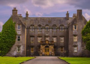
Recently published research from two sites at opposite ends of Scotland reveals new evidence for Bronze and Iron Age landscapes.

During archaeological investigations in advance of development at the Balvenie Distillery in Moray in 2014 and a housing development at Newton Mearns in East Renfrewshire in 2012, GUARD Archaeologists encountered pits and post-holes. These are relatively common on archaeological sites, and in some cases may be the only evidence of early settlement, but interpretation can be difficult. The post-holes and pits from these two sites were found in the lower contours of their respective upland areas, above 120 m OD. None of these was directly connected with other settlement remains and associated material culture was rare. However, radiocarbon dates reveal these features reflect activities during the Bronze Age and Iron Age periods and indicate that later prehistoric material can be found in upland areas even when significant changes to the landscape have occurred.

The alteration of the local topography at Balvenie, by the construction of a railway line in the nineteenth century and other ground-works in the middle to late twentieth century led to the reshaping of the hill slope. The pits and post-holes that survived indicated that the landscape had been topographically different when used by Bronze Age and Iron Age communities. The evidence indicates the seasonal gathering of hazel nuts for food, the possible cultivation of cereal crops, and certainly the processing of barley and even oats. It seems that barley has a long tradition of cultivation and use in this area and that Glenfiddich barley still plays a major role in the local economy, most significantly for the production of whisky.

The discovery of a pit with material cultural evidence in an area of rough grazing in Newton Mearns increases the sparse number of known prehistoric sites in this area. It is unlikely the area suffered the scale of landscape changes, seen at Balvenie, but changes will have taken place in vegetation cover and in the use of the land. The pit, together with the presence and of clay/daub and a possible quern fragment, indicates that the landscape was settled and used during the early Bronze Age, with nearby hazel, oak and willow woodland. The pit produced one of the earliest radiocarbon dates obtained from this area. Its presence suggests contemporary settlement may be preserved close by.

Through these two limited views of the past, our knowledge of human activities in these upland areas is increased. Even though the material cultural remains were sparse, the environmental evidence provided not only radiocarbon dates but suggest prehistoric landscapes very different to that of today.

The full results of this research, which was funded by William Grant and Sons Distillers Ltd and Stewart Milne Homes, ARO28: What pits and postholes can tell us: recent finds from Balvenie and Newton Mearns by Warren Bailie and Maureen Kilpatrick is freely available to download from the ARO website – Archaeology Reports Online.


Share this page

Unearthing prehistoric and early medieval Lothian

Share this page

Recently published research by Bob Will of GUARD Archaeology reveals the discovery of the complex history of settlement at a place in the Lothians of Scotland, from the Neolithic through the Bronze Age and Iron Age into the early medieval period.

This work was undertaken at Gogar Mains to the west of Edinburgh in advance of the construction of the Edinburgh Tram Scheme linking Edinburgh Airport with the city centre. Prior to the excavation several prehistoric archaeological sites were known in the immediate vicinity including cropmarks of two possible settlements. Within the wider locality, there is a wide range of known sites, including to the north the ‘Cat Stane’, with its early medieval Romano-British latin inscription and associated long-cist cemetery, as well as prehistoric remains consisting of Neolithic pottery and flint tools. There are also references to another long-cist cemetery to the south while further to the north is the Craigie hillfort and to the west is Huly Hill, an early Bronze Age mound and Iron Age Chariot burial as well as a medieval settlement.

The excavation was initially centred on the concentration of archaeological features revealed during an earlier evaluation. Once the topsoil was stripped, over 150 features were investigated, revealing seven discrete areas of activity that contained a range of botanical and artefactual evidence and radiocarbon dates that demonstrate that the site was in use over a long span of time between the early fourth millennium BC and the eighth century AD.

Neolithic activity was represented by pits containing hazel nutshell, flint tools and pottery sherds from carinated bowls, probably the debris from a Neolithic settlement. More clearly defined evidence for a house structure was apparent in the Bronze Age, in the form of a ring groove with internal post-holes, adjacent to a palisaded enclosure but there was little artefactual evidence and the dating of these structure derives solely from radiocarbon dates. These dates suggest two phases of construction or use of the palisade. There was little evidence for structures within the palisade, although several post-holes may indicate an internal supporting structure, or fence lines indicative of pens for livestock.

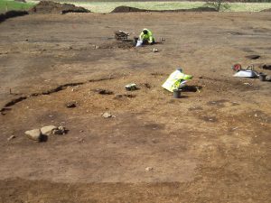
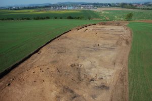
Two truncated roundhouses near the north end of the site were dated to the Iron Age. An associated fragment of a miniature quern was recovered; these tend to be found in the east of Scotland during the Iron Age. The final phase of activity on-site comprised the remains of two corn-drying kilns, dated to between the sixth and eighth centuries AD, that survived as oval pits containing considerable quantities of burnt and charred cereal grains. Associated with the better-preserved kiln was a rim sherd of coarse pottery and two fragments from a rough quern.

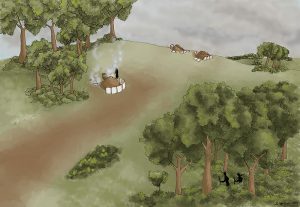
While the archaeological investigations provided evidence for occupation of this place over a long period of time, it was surprising that little evidence for settlement from the Roman occupation of southern Scotland was encountered, considering the presence nearby of a Roman fort, milestone and temporary camps. The archaeological remains from the excavation nevertheless provide a palimpsest of prehistoric and early medieval occupation and support similar occupation and settlement evidence from the wider region. The early medieval date for the corn-drying kilns provides direct evidence for settlement and agriculture, as well as a domestic setting for the long-cist cemetery at Catstane to the north. Together with another nearby long-cist cemetery to the south and contemporary field boundaries near Gogar Church, the results are combining to gradually fill out a picture of sustained settlement and agriculture in this area of the Lothians during the early medieval period.

The full results of this research, which was funded by the City of Edinburgh Council, Excavations to the West of Gogar Mains, Edinburgh by Bob Will with Heather F. James is freely available to download from the Scottish Archaeological Internet Reports website, published by the Society of Antiquaries of Scotland.

Share this page

Artefacts from the Castle Midden and Back Walk in Stirling

Share this page

Recently published research reveals a range of artefacts recovered from two sites on the edge of the medieval burgh and castle at Stirling.

Material from an eroding midden below the western walls of Stirling Castle was recognised and initially recovered by local volunteers and pupils from Allan’s Primary School over a number of years and led to a programme of artefact recovery supervised by Dr Murray Cook, Stirling Council Archaeologist.

Further south along the western edge of the medieval burgh of Stirling, GUARD Archaeologists recovered artefacts during a watching brief when a section of the Back Walk footpath was repaired.

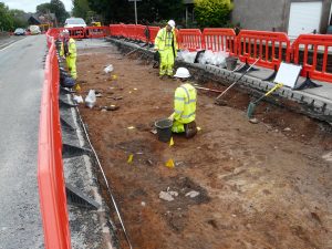
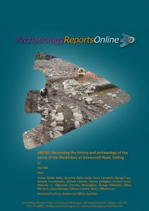
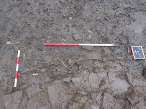
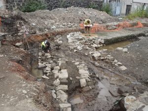
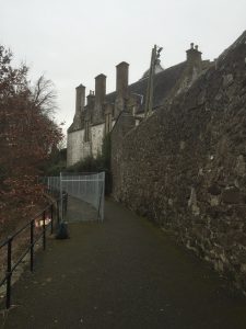
This section of footpath runs behind Cowane’s Hospital next to the Church of the Holy Rude and on the perceived line of the Stirling town wall, which was constructed sometime in the sixteenth century.

Over 2000 artefacts in total were recovered; they included medieval and post-medieval pottery, a misshapen musket ball, as well as modern glass and ceramics. Subsequent post-excavation analyses of these artefacts were co-ordinated by GUARD Archaeology Ltd.

The material seems to have been deposited as rubbish simply by dumping it over the edge of the crag and certainly the small abraded nature of even the ‘modern’ pottery would suggest that the material had been moved or re-deposited over time after the initial discard.

Among the medieval and post-medieval assemblages are examples of the main pottery fabric types found in Scotland, as well as imported material from England and mainland Europe. These give an indication of the importance of local pottery production as well as further away trade links to the burghers of Stirling throughout the centuries. Numerous clay tobacco pipe fragments were also recovered from both sites, mainly of post-1850 date, but the assemblage includes four bowls from the seventeenth century.

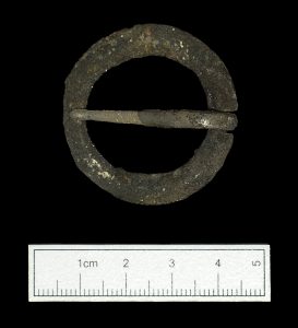
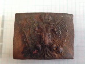
One of the more unusual artefacts to be recovered from the Back Walk was a WWI military belt buckle. The military buckle is from the Austrian army and has the double headed imperial eagle and the Austrian coat of arms and is one that was standard issue during WWI.

‘Unfortunately, the buckle was a stray find so we don’t know how it got to the Back Walk, whether it was lost or thrown out,’ said report author Bob Will from GUARD Archaeology. ‘Stirling Castle was an important working military barracks at the time with a military prison and hospital therefore the buckle could have come from a prisoner or it could have been picked up by a British soldier serving at the front. As this year commemorates the centenary of the end of WWI the buckle reminds us that the war had far reaching affects throughout the country.’

The full results of this research, which was funded by Stirling Council, ARO27: The Artefacts from Castle Midden and Back Walk, Stirling by Bob Will is freely available to download from the ARO website – Archaeology Reports Online.

Share this page