Category Archives: 2019 News

Wilkhouse Inn – no drovers return

Share this page

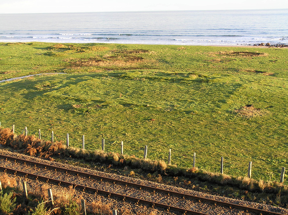
New insights into Highland life immediately before the Sutherland clearances of the early nineteenth century, have just been published in Archaeology Reports Online.

The investigations at Wilkhouse in Sutherland, led by GUARD Archaeology, were centred upon an eighteenth-century drovers’ inn and its neighbouring buildings. The evidence reveals a place pivotal to the local economy, where the continuity of settlement within the Highlands was in the process of developing into modernity before being cut short by the clearances instigated by the Sutherland Estate.

‘We revealed evidence of inhabitation here over a long period,’ said GUARD Archaeologist Warren Bailie, who directed the excavation. ‘The stone foundations of an earlier structure were found under the north-east gable of the inn while the coin assemblage testifies to the long-term use of the drove road at least as far back as the late sixteenth century. Earlier antiquarian finds, nearby, indicate occupation in the Norse, Pictish and Iron Age periods. The excavation also found a buried Neolithic occupation layer below one of the inn’s outbuildings.

The inn at Wilkhouse was a statement of modernity and affluence when built in the eighteenth century. It was constructed with harled stones, lime mortar bonding, glass windows, double chimneys and a slate roof. The level of investment suggests that there was ample passing trade to warrant the spend and was very much in contrast to many other drovers’ inns in Scotland, which were often a longhouse built of drystone with wooden shuttered windows, low walls, central hearths set on the floor and a turf or thatched roof.

General shot of the site; the remains of Wilkhouse Inn lie near the top left

The process of change also brought about its demise. The roadway was moved up the hillside and out of sight. Competition from newer inns in Brora and Helmsdale would have been damaging. However, underlying these lay the demands of the Sutherland Estate. The Kintradwell estate, recently subsumed again into Sutherland ownership after a period in the hands of the Gordons of Carroll, was cleared of its people in 1819. The inn was not be spared and by the coming of the railway in 1870 had sank into obscurity and was little more than a ruin.

‘A revealing description of Wilkhouse Inn in 1802 written by the Rev Donald Sage gives a picture of what was lost when the inn was forcibly closed in the name of improvement’, said Donald Adamson:

“We stopped for refreshment at an inn below Kintradwell, called Wilk-house, which stood close by the shore. This Highland hostelry, with its host Robert Gordon and his bustling, talkative wife, were closely associated with my early years, comprehending those of my attendance at school and college. The parlour, the general rendezvous for all comers of every sort and size, had two windows, one in front and another in the gable, and the floor of the room had, according to the prevailing code of cleanliness, about half an inch of sand upon it in lieu of carpeting. As we alighted before the door we were received by Robert “Wilkhouse” or “Rob tighe na faochaig” as he was usually called, with many bows indicative of welcome, whilst his bustling helpmeet repeated the same protestations of welcome on our crossing the threshold. We dined heartily on cold meat, eggs, new cheese, and milk. “Tam,” our attendant, was not forgotten; his pedestrian exercise had given him a keen appetite and it was abundantly satisfied.”

‘Thus, we meet “Rob of the House of the Whelks” as he was known in the district,’ said Donald Adamson. ‘Alongside him was his wife Kirsty Fraser, who may have been the daughter of the previous innkeeper, William Fraser. Donald Sage’s meal might have been representative of standard fare at Wilkhouse. Milk, cheese and eggs supplementing cuts of mutton and beef, although not necessarily the most prestigious cuts. However, the archaeological evidence reveals that the diet appears to have been more varied, with rabbits, birds (including auks) and fish on the menu. In addition, marine shellfish and notably whelks were eaten.’

An artist’s impression of drovers arriving at Wilkhouse in the eighteenth century

A visitor around 1800 would have seen the inn as distinctly modern in comparison with the three vernacular buildings surrounding it. It was representative of modernity and all that that implied at a time when farming patterns and landscape use were changing across the Scottish Highlands,’ added Donald Adamson, whose research into drove roads instigated the excavation. ‘Every other structure referred back in time to building methods and knowledge which had gradually accumulated in the locality. In a sense therefore, the inn represented something intrusive in the landscape.’

Inverted cross carved into one of the fireplaces of the inn

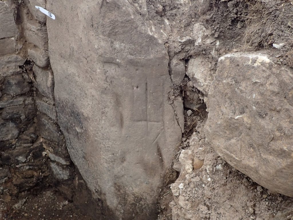
The new archaeological evidence found on site weave a rich picture of life in the years leading up to 1819. A curious inverted cross was carved into one of the hearth stones and may have been intended to deter witches flying down the chimney. Shards of ‘firing’ or ‘shot’ glass evokes a picture of toasts being exchanged after a meal or drinking session, with the noise of the glasses being slammed down on a table echoing through the inn. The majority of coins relate to the last phase of Wilkhouse operating as an inn. Most are halfpennies of the reigns of George II and George III, although there is also a Parys Mine token, valued at one penny, dated 1788. The distribution of finds indicate that many were dropped in an enclosure at the rear of the inn which might have been the area for unsaddling.

Four earlier coins suggest that the site was occupied in the seventeenth century and before. The earliest coin is a billon hardhead (two pence Scots) of James VI, dated 1588, which seems to have been dropped in the 1590s. There are then two ‘turners’, one a Scottish copper turner of the 1640s, also worth two pence Scots, and the second a French royal issue ‘double tournois’, dated 1628, of Louis XIII. The probability is that both circulated through much of the seventeenth century. The fourth coin is from the reign of Charles II, dated 1681 and is an Irish copper halfpenny.

Personal items recovered during the excavation including pins, buckles, strap fittings, thimbles and a part of a comb add colour to the domestic context of the buildings. Two military buttons of the Sutherland Fencibles, one possibly belonging to an officer, suggest that the inn was a meeting place for a company of soldiers in the period 1793 to 1801, when Britain was being defended against the possibility of French invasion by militia.

The trade patterns which had sustained Wilkhouse Inn, up to and through the Napoleonic wars, with its cattle stance to one side, were about to suffer a convulsive shift as ‘Improvement’ took a grip in the northern Highlands. An agricultural economy based on subsistence farming carried on by a network of sub-tenants, which relied on the export of black cattle as the cash crop, was about to be replaced by huge sheep farms, which were let directly to the highest bidders without consideration for family ties. In the case of Sutherland, this involved the movement of most of the people from the interior of the county to the coast, to the Lowlands and abroad. The cattle drovers were replaced by shepherds. The lands were cleared, the buildings forcibly abandoned, roofs removed and the people scattered.

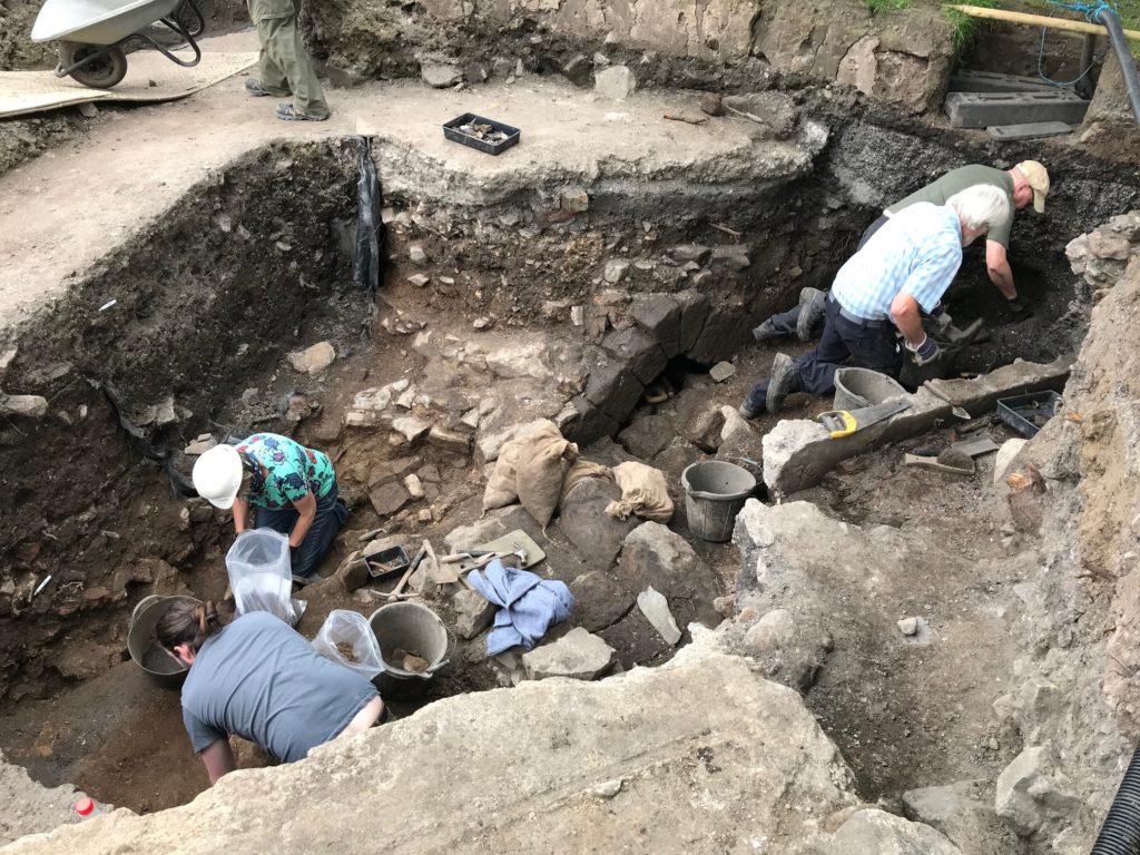
The excavation was undertaken in 2017 for Dr Donald Adamson who had completed a study on droving routes in the Scottish Highlands. The excavation involved collaboration between Clyne Heritage Society, the University of Glasgow and GUARD Archaeology, and provided training for early career archaeologists and also volunteer opportunities for members of the local and wider community.

ARO37: Wilkhouse: An Archaeological Innvestigation by Donald Adamson and Warren Bailie is freely available to download from the ARO website – Archaeology Reports Online.

Share this page

Paisley Abbey’s Great Drain Unearthed

Share this page

Centuries-old mystery of Paisley Abbey medieval tunnel is revealed

We already knew Scotland’s finest and best-preserved medieval tunnel lies buried beneath Paisley town centre – but the centuries-old mystery of where it ended had never been solved…until now.

A team of volunteers led by GUARD Archaeologists spent the summer excavating Paisley Abbey’s Drain and found a well-preserved fourteenth century stone archway marking the exact point the drain and its contents once flowed into the River Cart. They established the tunnel – believed to be around 100m long – ends around 3m from the banks of the present-day river, which would have been wider and shallower at the time the drain was built.

And while the find is now being covered up again, the discovery could help lead to a more permanent visitor attraction being built in the future allowing people to go inside the drain.

Excavation leader Bob Will said, ‘We found more than I was expecting and it is really exciting. We found the end of the drain and what was the boundary wall of the monastery. The river was wider and shallower in those days – much more than in the last couple of hundred years, as the walls now surrounding it are artificial. The main parts of the drain date back to the mid-fourteenth century and are incredibly well preserved.’

The Abbey Drain had lain hidden for centuries until it was unexpectedly rediscovered in the nineteenth century, and in recent years, it has been periodically opened up for visitors. There will be an opportunity for the public to put their names forward for a ballot to go inside it during this year’s Doors Open Day in September.

And Bob believes the finds of the past few weeks could help the development of a more permanent attraction opening up a greater degree of public access to the drain. He said: ‘What we have uncovered has helped us see what could be done with any future excavation. We now know much more about the mediaeval ground levels and have a good idea where some of the monastery buildings were. Ideally there would be more permanent access to the drain at some point in the future and what we’ve uncovered here makes that much more feasible.’

Renfrewshire Council leader Iain Nicolson added: ‘Paisley is already on the map as a key visitor destination within Scotland and we are already delivering on ambitious plans to use our unique heritage to drive new footfall to the town centre. We would be keen to explore any opportunities to build on that by opening up more permanent access to the Abbey Drain at some point in the future – and the findings of the Big Dig mean we now know more than ever about this incredible feature beneath the town centre. The Big Dig was a really great community project which has created a lot of interest in Paisley town centre and its history over the past couple of months. We would like to thank our funders for helping make it happen, and all who have been involved in the projects – particularly the local volunteers who came out in all weathers to take part.’

The eight-week Abbey Drain Big Dig was co-ordinated by Renfrewshire Council and led by GUARD Archaeology Ltd, with funding from National Lottery Heritage Fund and Historic Environment Scotland. It also saw a strong community element, with volunteers from Renfrewshire Local History Forum taking part in the dig, students from the University of the West of Scotland filming it, and a series of events and seminars for residents and visitors.

Share this page

Insights into Neolithic and Bronze Age Lanarkshire

Share this page

In 2015, GUARD Archaeology Ltd carried out an excavation in advance of a housing development at Colinhill on the outskirts of Strathaven in South Lanarkshire. The work, which has just been published, revealed two adjacent but distinct Bronze Age roundhouses dating to the mid-second millennium BC and two Neolithic pit groups dating to the fourth millennium BC.

The Neolithic pit groups are indicative of nearby inhabitation. Radiocarbon dates indicate that although the two groups fall broadly within the early and the middle Neolithic (3700–3000 BC), they likely date to either extreme of this and could be up to 700 years apart in origin. The artefactual assemblages present within the pits are typical of those associated within the earlier Neolithic period. These assemblages include a range of Carinated Bowl pottery, pitchstone tools, worked stone tools, axe-head fragments and burnt bone and stone fragments. Both the earlier and latter group of Neolithic pits at Colinhill all comprise un-weathered pits with all but one containing a single mixed deposit, suggesting that the material may have been worked and mixed prior to a swift deposition after the feature was dug. The presence of the two groups around 180 m apart suggest that the upper slopes of Colinhill were sporadically revisited.

Early Neolithic pits at Colinhill

The particularly high proportion of pitchstone, which originates from Arran, could be connected to the sites’ proximity to Biggar, which has been previously identified as an area of high pitchstone concentrations. The pottery assemblage also reflects shared attributes of style and technique evident across several Neolithic sites in south-west Scotland. Altogether these provide insight into the exchange of materials and ideas across southwest of Scotland.

The two roundhouses on the other hand date to around the middle centuries of the second millennium BC – the middle Bronze Age – though it is unclear if they were at any point contemporary with each other. Radiocarbon dating shows that Roundhouse A may have been slightly earlier but there is a possibility that occupation of the two structures overlapped in time. The evidence within both roundhouses for repairs certainly suggests that attempts were made to prolong the life of each structure.

Both roundhouses appear to be typical of a turf or earth constructed ring-bank and post-built structure with east facing entranceways. Given the scale and arrangement of the structure along with the presence of domestic waste material within the post-holes, it seems feasible that both were primarily domestic structures. The 9.1 m diameter of Roundhouse B and 9.5 m diameter of Roundhouse A are also roughly typical of similar structures in western and southern Scotland at this time.

Significantly, both roundhouses share the presence of much earlier Neolithic material. While some of these objects are small enough that they may have originated from the earlier Neolithic activity on the site and ended up unintentionally within the backfill of Bronze age post-holes and ditches; this becomes less likely for the much larger Neolithic objects,  leaf-shaped flint arrowhead and a pitchstone core, recovered from Roundhouse B. It seems probable that there was an intentional aspect to the deposition of these objects, which may have been found by the later Bronze Age inhabitants who retained them for their ‘exotic’ form and material. This makes consideration of the lifecycle of these objects particularly interesting, with it being possible that they may have been deposited with a ritual aspect twice, over a millennium apart; firstly, as part of the structured deposition of an early Neolithic Carinated Bowl assemblage from a nearby pit, and then again on their discovery in the middle Bronze Age as part of the roundhouse construction.

The archaeological works were funded by Stewart Milne Homes, Robertson Homes and L S Smellie and Sons Ltd. ARO35: Neolithic pits and Bronze Age settlement at Colinhill, Strathaven by Beth Spence with contributions from Torben Bjarke Ballin, Beverley Ballin Smith and Susan Ramsay, is freely available to download from the ARO website – Archaeology Reports Online.

Share this page

Unearthing the secrets of Paisley Abbey

Share this page
Paisley Abbey

The biggest-ever exploration of one of Renfrewshire’s most mysterious historical features is now underway – and hopes to unveil some centuries-old secrets.

An archaeological dig led by GUARD Archaeology has started at Paisley’s Abbey Drain – a complex underground structure which links the town’s 850-year-old Abbey to the River Cart. The 100m long underground passageway, thought to be more than 700 years old, was unearthed in the 19th century and rediscovered in the 1990s. The Big Dig hopes to uncover more about the passageway and reveal more about life in Paisley hundreds of years ago.

Paisley Abbey’s Great Drain

Initial excavations of the site unearthed the earliest polyphonic musical notation and the largest collection of medieval pottery ever found in western Scotland – and it is hoped that this two-month long project will uncover many more secrets.

The Big Dig also includes an extensive programme of activity to involve the local community. Students at the University of the West of Scotland will create a series of short films and a documentary on the drain, and there will also be school visits, volunteering opportunities, and free talks and workshops for the public.

Launching the Big Dig last week

Members of the public will not have access to the drain during the Big Dig – but there will be a chance for residents and visitors to go inside it, as in previous years, during the Doors Open Days weekend on 7 and 8 September. To keep an eye on Big Dig progress, visit www.paisley.is

The dig is managed by Renfrewshire Council, run by GUARD Archaeology with help from Renfrewshire Local History Forum volunteers, and supported by funding from the National Lottery Heritage Fund and Historic Environment Scotland. 

Share this page

New Evidence for Roman Conquest of Scotland

Share this page

GUARD Archaeologists have discovered a hitherto unknown Roman marching camp that was constructed during the Roman conquest of Scotland, new publications reveal.

Formation of Roman Camp at Ayr and radiocarbon dates © GUARD Archaeology Ltd

The discovery was made during archaeological excavations undertaken by GUARD Archaeology prior to the building of the new Ayr Academy in 2015. At the time it was not obvious that a Roman camp had been found, because there were no Roman artefacts present, only fragments of much earlier Neolithic pottery and an Iron Age bangle from a seemingly random spread of pits and post-holes. However, during the subsequent post-excavation analyses, radiocarbon dates revealed a regular pattern of features that date to the Roman conquest of Scotland in the latter part of the first century AD.

Stone-lined oven and rake-out material at Ayr Academy © GUARD Archaeology Ltd

‘The Roman features comprised 26 large, often double, fire-pits that were distributed evenly in two parallel rows 30m apart,’ said Iraia Arabaolaza, who directed the excavation. ‘The arrangement and uniformity of these features implies an organised layout and the evidence suggests that they were all used for baking bread. The location of the oven was recognised by the scorching of the subsoil base, stone slabs and burnt clay fragments, some with wood imprints and with dome moulding. Ash pits were identified at the opposite end to the ovens within these figure-of-eight features, filled with burnt and charcoal-rich soil comprising the raked-out material from the clay-domed ovens.’

The radiocarbon dates from these fire-pits overlapped between the years AD 77-86 and AD 90, which accords with the conquest of Scotland by the Roman general Agricola from AD 79 until AD 83 and the subsequent Roman consolidation. Agricola’s son-in-law, Tacitus, who wrote an account of the yearly campaigns, reported that “in the fifth campaign, Agricola, crossing over, subdued, by frequent and successful engagements, several nations till then unknown; and stationed troops in that part of Britain which is opposite to Ireland.”

Until now, the only two known routes for the Roman invasion of southern Scotland were further to the east; the present-day M74 and A68 roads follow these same courses. But the new marching camp at Ayr reveals another route down the west coast towards the south-west tip of Scotland, from where Ireland is readily visible.

Map of Agricola’s army’s marching camps across Scotland © GUARD Archaeology Ltd

‘There was a ford across the river Ayr just below the Roman marching camp while ships may have been beached on the nearby shoreline’ said Iraia Arabaolaza. ‘The Ayr marching camp is 20 miles from the nearest Roman camp to the south at Girvan, which corresponds to a day’s march for a Roman soldier. There is a little more distance to other Roman camps to the north-east near Strathaven. Altogether this suggests that this site was chosen as a strategic location for the Roman conquest of Ayrshire.’

Roman marching camps have been described as the temporary bases of a tented army on campaign. Whilst most Roman camps are usually recognised by the regular linear ditches that enclose them, landscaping or ploughing at the Ayr Academy site appears to have destroyed any such remains. The camp at Ayr Academy, however, shares other similarities with Roman camps in Scotland, which have also revealed similar formations of fire-pits or camp-ovens. The distance of 30m between the two rows of fire-pits at Ayr Academy accords closely to the length of area allocated to the ten tents of a century in ancient Roman military manuals. The rectangular formation of fire-pits at Ayr Academy may represent the ground where up to eight centuries, amounting to 640 legionaries, were once encamped. It is also possible that the archaeological remains only represent a portion of the camp, which may have extended into the flat land to the north, where the modern racecourse is situated.

Fragment of shale bracelet from Ayr Academy © GUARD Archaeology Ltd

The Romans, of course, were not the first people to occupy this site. While little trace of the local Iron Age people was recovered during the excavation, save a fragment of a shale bracelet which might date to this same period, the GUARD archaeologists uncovered numerous pits and post-holes that date to much earlier times.

Evidence for Bronze Age ritual activity from the late third and second millennium BC, a Neolithic settlement from the fourth millennium BC and a Mesolithic hunter/gatherer camp from the sixth millennium BC was also discovered, revealing this to be one of the earliest and most complex prehistoric sites in this area of the west coast of Scotland. To put this into perspective, the earliest occupation of the Ayr Academy site goes back to around 5200 BC, roughly 2½ times as old as the Roman Marching Camp is to us. As the excavation at Ayr Academy demonstrates, Scotland was not an untouched wild landscape that the Romans marched into in AD 79 but already an ancient land inhabited by communities whose culture and heritage stretched back millennia.

The archaeological work was funded by Kier Construction Ltd and was required as a condition of planning consent by South Ayrshire Council who are advised on archaeological matters by the West of Scotland Archaeology Service, who considered there to be a potential for hitherto unknown archaeology to be buried at the site due to the proximity of known prehistoric archaeology.

A Roman Marching Camp in Ayr by Iraia Arabaolaza is published in the Britannia Journal, while ARO33: Beside the River Ayr in prehistoric times: excavations at Ayr Academy by Iraia Arabaolaza is freely available to download from Archaeology Reports Online.

Share this page