Category Archives: 2021 News

Revealing the prehistoric origins of Scotland

Share this page

Hadrian’s Wall is often blamed for splitting Ancient Britain in two but newly published archaeological research reveals that the peoples of Scotland and England were already culturally divergent long before the Romans arrived in Britain.

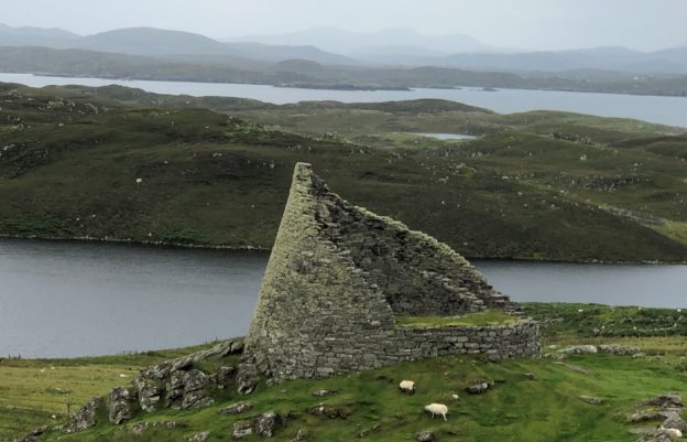
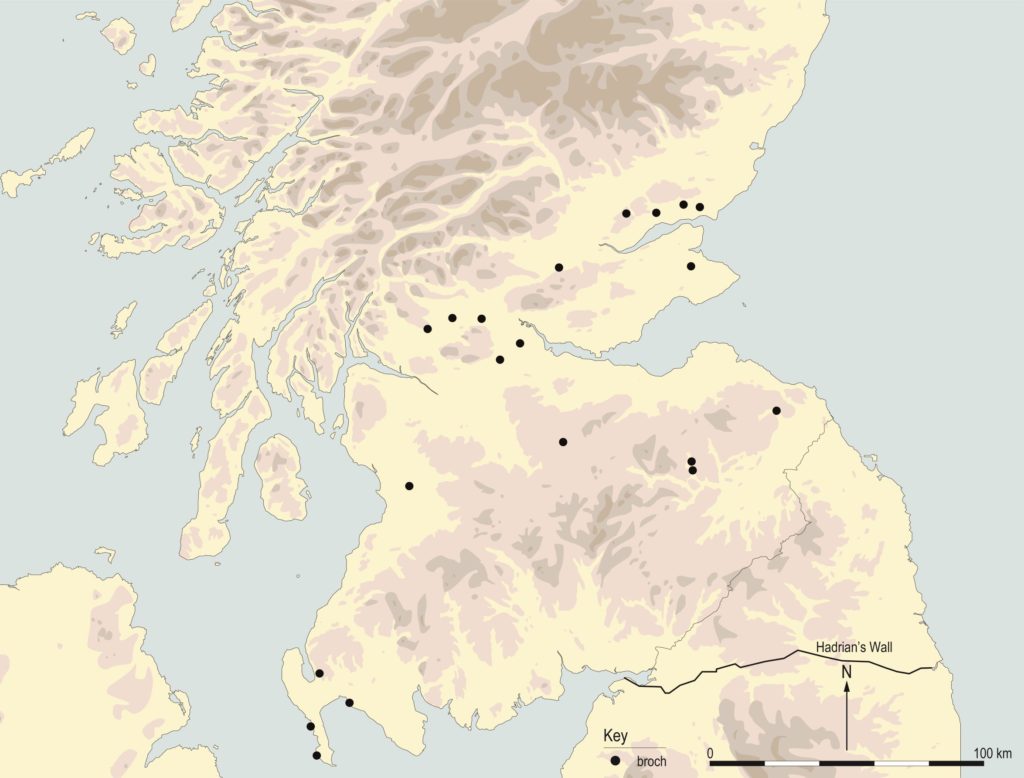
An array of brochs, duns, crannogs and souterrains are found widely across Scotland but are not evident in northern England or further south. Surprisingly, that various types of Iron Age settlement do not breach the Anglo-Scottish border is something that has not been examined in detail, until now.

Distribution maps of crannogs, souterrains, brochs and duns © GUARD Archaeology Ltd

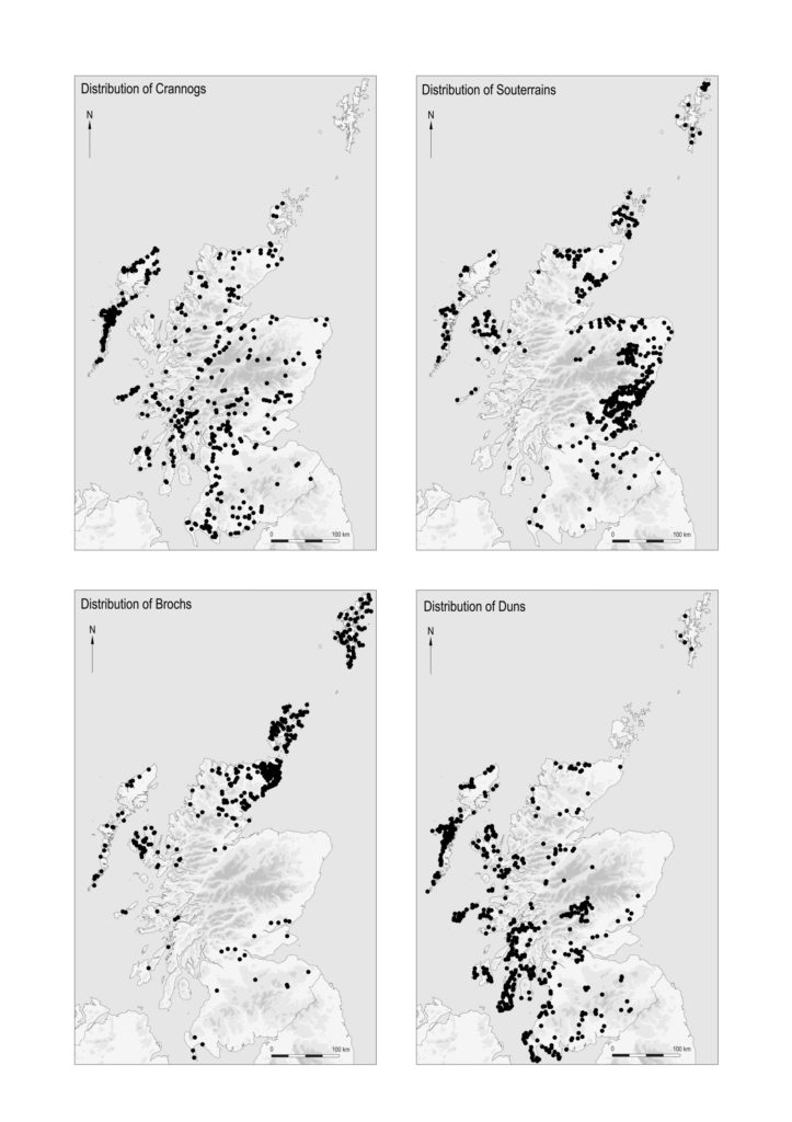
‘The underlying implication of the settlement distribution patterns is that Iron Age societies across Scotland were open to the building and occupation of brochs, crannogs, duns and souterrains but that Iron Age societies further south were not,’ said GUARD Archaeologist Ronan Toolis, who conducted the research. ‘This was the result of cultural choices taken by households and communities, not environmental constraints, and suggests that Iron Age societies north and south of the Tweed–Solway zone were perceptibly dissimilar. And while the density of brochs, crannogs, duns and souterrains varies across Scotland, this reflects not so much a patchwork but a spectrum of settlement patterns.’

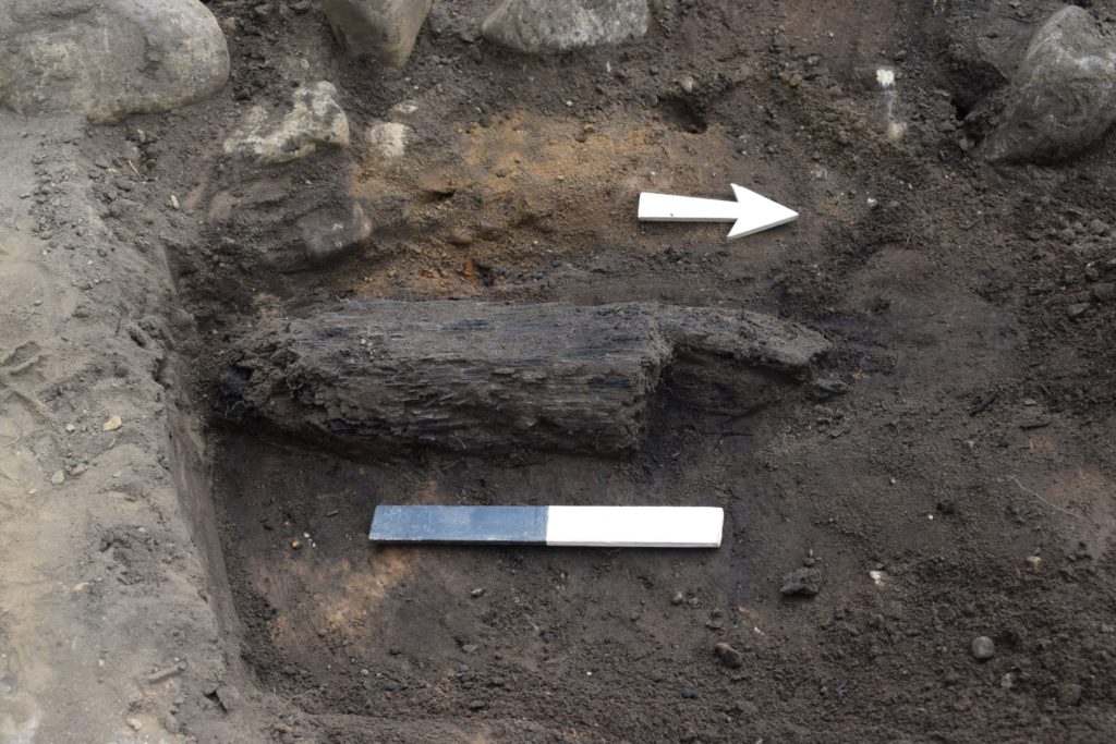
These distinctive differences in the archaeological record are especially significant because the construction of crannogs and souterrains during the 4th-2nd centuries BC demonstrates that this divergence occurred long before the Roman frontier zone may have severed societies.

‘The archaeological divergence does not equate with the line of Hadrian’s Wall but rather more closely with the Anglo-Scottish border,’ added Dr Toolis. ‘The Wall instead follows probably the best strategic course through a broader zone of cultural divergence.’

And this may have played a crucial part in explaining why the Romans failed to absorb Scotland into their empire, despite three major military campaigns that appear, at least in Roman accounts, to have been overwhelmingly successful. This failure is often attributed to the changing political and military priorities of Rome but it may owe more to the nature of Iron Age society in Scotland, which archaeologists are beginning to recognise was anarchic in nature – not chaotic but composed of autonomous households and communities lacking institutionalised leadership. Unlike the tribal kingdoms the Romans encountered to the south.

Clear evidence for the adoption of Roman culture does not occur in Scotland until the 5th century AD, after the Romans had abandoned Britain, when secular as well as ecclesiastical Latin inscribed stones, bearing Latinised names of indigenous inhabitants, and Christian terminology and symbols, were erected across southern Scotland.

‘This only occurred when Iron Age society in Scotland had become hierarchical,’ said Dr Toolis. ‘The evidence implies that far from being passive participants in acculturation, it was only with their active participation and likely at their own instigation and on their own terms, that communities in Scotland truly adopted aspects of Roman culture.’

Distribution of Pictish symbols, British silver chains and Romano-British Latin Inscribed Stones © GUARD Archaeology Ltd

Moreover, expressions of power and prestige distinctive to early medieval Scotland suggest profound cultural divergence continued in the centuries that followed the demise of Roman Britain.

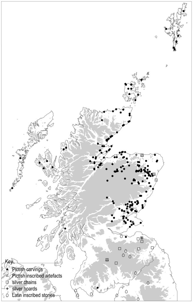
Pictish symbols, whether carved on stone or inscribed upon artefacts like massive silver chains and silver ornaments, are only found in Scotland. While these are overwhelmingly concentrated north of the Forth, they are also encountered within non-Pictish contexts to the south and west in the Lothians, Lanarkshire, Galloway and Argyll. The direction of influence was not one-way. Massive silver chains, which are also unique to Scotland, are concentrated in the south-east of the country, reflecting their cultural origin here, the result of the appropriation of Roman silver as a way of expressing status and power. That silver chains are also found north of the Forth but not south of the Tweed and Solway demonstrates yet again mutual cultural values in the expression of power and prestige among the Britons of southern Scotland and the Picts of northern Scotland, but not apparent among the Britons, Angles and Saxons of England and Wales.

Distribution of nucleated forts and contemporary settlements of sixth and seventh centuries AD © GUARD Archaeology Ltd

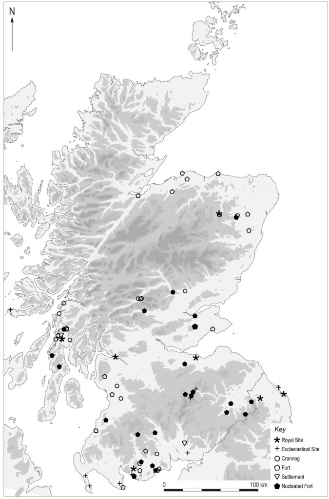
Nucleated forts, a type of early medieval hillfort unique to Scotland, are also absent south of the border. These often occur in discrete clusters of elite settlements – in Galloway, Argyll, the Scottish Borders, Fife, Tayside and Aberdeenshire. Excavations have revealed several of these forts to be royal strongholds with evidence for international trade, the manufacturing of gold and silver jewellery and royal inauguration rites. Similar sized clusters of prominent households occupying brochs across lowland Scotland during the first two centuries AD may represent an Iron Age precursor to the pre-eminent households that emerged in the 5th–7th centuries AD.

‘It may be that the clusters of early medieval elite settlements reflect how society in Scotland was replicating a process of households accruing power and status that had been arrested in development, either because of Roman aggression or internal social upheaval, during the early centuries AD,’ said Dr Toolis.

Map of brochs across lowland Scotland © GUARD Archaeology Ltd

‘While there existed cultural affinity in some aspects north and south of the border and regional variation is apparent within Scotland itself,’ added Dr Toolis, ‘these do not negate the cultural divergence apparent north and south of the border and the aspects of cultural affinity that the regions of Scotland uniquely share. Just as it is possible for local patterns to be distinguished from regional trends in Iron Age culture in Scotland, so too is it possible to recognise national trends. However, culture should not be conflated with identity. The peoples of early medieval Scotland may have separately identified as Britons, Picts and Scots but they nevertheless shared cultural traits unique to Scotland.’

The archaeological evidence suggests that Hadrian’s Wall was not a cause but instead an effect of existing cultural differences between the peoples of what later became Scotland and England, and this cultural divergence continued beyond into the medieval period. Separate cultural trajectories led to the separate formations of the two kingdoms, entirely independent of Hadrian’s Wall.

Shifting perspectives on 1st-millennia Scotland by Ronan Toolis is published in the latest Proceedings of the Society of Antiquaries of Scotland.

Share this page

GUARD Archaeology nominated for 2022 Current Archaeology Award

Share this page

GUARD Archaeology’s work exposing the heart of prehistoric Galloway has been nominated as a candidate for Rescue Project of the Year in the 2022 Current Archaeology Awards!

The project is: Road to the past: exploring the prehistoric heart of Galloway an account of our excavations of a range of Mesolithic, Neolithic, Bronze Age and Iron Age sites in advance of the Dunragit bypass. This work revealed around 8,000 years of human activity within a rich and complex historic landscape on the south-west coast of Scotland.

Voting for the awards opens today and will close on 7 February 2022 – the results will be announced on Current Archaeology’s Youtube channel on the evening of Friday 25 February 2022.

Voting is open to everyone. For details of the awards and how to vote, go to: www.archaeology.co.uk/vote

Share this page

The early prehistoric origins of Blairgowrie and Rattray

Share this page

Archaeological excavations in Blairgowrie and Rattray this year have revealed prehistoric roundhouses and metalworking that may be over three thousand years old.

Remains of one of the roundhouses revealed at Rattray, comprising the ditch of an outer wall and internal rings of post-holes © GUARD Archaeology Ltd

The discovery was made during archaeological excavations undertaken by GUARD Archaeology in advance of a housing development at Honeyberry Crescent in Rattray. The remains of eight buildings were revealed, along with a rare metal working hearth. Amongst the finds were two tuyere fragments – clay nozzles that protected bellows used in heating the prehistoric smiths’ forges. These are uncommon finds and may help the archaeologists study the techniques used by the smiths here to create metalwork. Preliminary analysis of finds recovered from the excavation suggests that the site was used from the Neolithic to the Iron Age.

One of the tuyere fragments found at Rattray © GUARD Archaeology Ltd
Burnt wood found within one of the roundhouses at Rattray © GUARD Archaeology Ltd

‘The presence of an early settlement at Rattray is unsurprising as the area is rich in prehistoric archaeological remains’ said GUARD Archaeologist Maureen Kilpatrick, who directed the excavation. ‘The structures correspond to two of the main architectural types of Bronze Age houses. The pottery fragments found within some of these structures have also been tentatively dated to the Bronze Age. One of the structures was particularly interesting as it was the only one to have evidence that it had been burnt down prior to being rebuilt in a completely different architectural tradition. A large fragment of burnt wood which might represent a structural element from the burnt down roundhouse was recovered during the excavation, which is in itself rather interesting as it can help in our understanding of the method and materials used during housing construction in the past.’

‘Radiocarbon dating and analysis of the finds will enable us to understand these prehistoric households and whether the buildings were contemporary with each other and therefore a village perhaps, or whether these houses represent the consecutive homes for a single household that occupied this site over many generations perhaps from the Bronze Age and on into the Iron Age,’ added GUARD Archaeologist Eleanor James, who supervised the excavation.

Share this page

A well-trodden prehistoric path

Share this page

The earliest known use of the upland areas of East Renfrewshire during the Neolithic and Early Bronze Age periods has recently been unearthed by GUARD Archaeology.

A newly published report reveals the results of GUARD Archaeology’s excavations at Maidenhill on the southern outskirts of Newton Mearns in East Renfrewshire, conducted between 2017 and 2018. The remains of early Neolithic and later pits, and evidence of Bronze Age burial practices were uncovered. Radiocarbon dates were obtained from a variety of features indicating activities throughout much of the fourth millennium BC and the second half of the third millennium BC.

‘The ceramic assemblage from Maidenhill, when viewed with associated artefacts and comparison of features in which it was found, displays remarkable similarities with other archaeological sites in Ayrshire and South Lanarkshire,’ said Beverley Ballin Smith, who analysed the pottery fragments from the site. ‘A common culture is embedded in the pottery – in vessel manufacture, in shapes, designs and decorative motifs and the placement of those motifs. There may be slight differences in the execution of designs, indicating individual potter’s interpretations of the attributes of that common culture, but overall suggests close association between settlements of the Neolithic and Early Bronze Age in this part of Scotland.’

‘The evidence people left behind provides a picture of activities from the very end of the late Mesolithic, through the early and middle Neolithic, and into the early Bronze Age,’ said Maureen Kilpatrick who led the excavations. ‘As no permanent settlement was discovered, this landscape seems to have been a zone of transition, with people moving through it: they camped for what appears to have been short periods of times, and at certain times of the year. From the almost ubiquitous occurrence of hazel nutshells from pit fills, autumn seemed to be the time of greatest activity – gathering wild food, perhaps even hunting, as bones and flint fragments indicate. Grains of cereals were absent reinforcing the suggestion that travellers lived off the land.’

Excavation of a posthole alignment at Maidenhill © GUARD Archaeology Ltd.

The prehistoric camp sites are marked by fire-pits, refuse pits, the occasional post-hole and stake holes. After use some of the pits received deposits of specific items. These included ‘exotic’ items of pitchstone, a fragment of a polished stone axe, and Antrim or Yorkshire flint, all from beyond the immediate area, as well as sherds of locally made pottery, which could have had meaning beyond that of the commonplace disposal of rubbish. Pits with similar ‘special’ deposits have been found in the wider area such as at Strathaven in South Lanarkshire, at Hillhouse in South Ayrshire and Drumclog in South Lanarkshire. The movement of peoples carrying with them exotic pieces of stone indicate that there may, already in the early Neolithic, have been established routes between the Firth of Clyde and Irish Sea area to the Firth of Forth and the North Sea.

‘The evidence revealed by the excavations at Maidenhill is important,’ added Maureen Kilpatrick, ‘as it indicates that prehistoric activity was occurring from an early period around the edges of the upland areas, and that those individuals who passed through this landscape brought with them ideas and practices from further afield.’

The archaeological work at Maidenhill was commissioned by CALA Homes (West) and Taylor Wimpey. ARO46: A well-trodden path: the prehistoric landscape of Maidenhill, Newton Mearns, East Renfrewshire by Maureen C. Kilpatrick is freely available to download from the ARO website – Archaeology Reports Online.

Share this page

A lang view of the landscape around Edinburgh

Share this page

Newly published research reveals a changing landscape on the edges of Edinburgh, from medieval farming through the industrial revolution to the current housing boom as the city expands.

Prior to a residential development at Lang Loan on the southern outskirts of Edinburgh, GUARD Archaeology Ltd undertook a metal detecting survey, trial trench evaluation and excavations that revealed 118 archaeological features associated with medieval rig and furrow agriculture, coal extraction and limestone quarrying dating from the seventeenth to the nineteenth centuries.

The earliest features uncovered on the site, comprising rig and furrow, relate to medieval farming practices. Residual medieval material was recovered from a ditch running parallel to a limestone quarry scar and assumed to be part of a drainage system related to the later quarry. This material included pottery fragments of a large cooking dish dating to the late thirteenth or early fourteenth century. Environmental analysis recovered evidence of carbonised cereal grains, mainly oats but also a small amount of barley and rye. A fragment of hazel charcoal was also recovered and together with an oat grain was subject to radiocarbon dating which provided a consistent date of mid twelfth century to mid thirteenth century. Their presence is suggestive of grain-drying and possibly malting activity in the vicinity. The drying of grains using a kiln was necessary for milling wheat and oats, and for the germination of barley for brewing. Within this process any burnt grains are cleaned out of the kiln and swept aside into the surrounding area. While any evidence of a kiln has been lost, the linear drain may have accumulated earlier soil deposits before further quarrying activity and significant industrial contamination of the landscape took place.

From the early seventeenth century onwards, small exploratory coal pits evidently peppered the landscape. Fragments of eighteenth-century bottle glass dating to the period c. 1690-1710 may relate to the earliest coal mining activity that is documented in this area. By the early nineteenth century coal shafts had been sunk and large open-cast limestone quarries cut through the fields. The limestone quarrying scars represent the impact of industrial activity on the landscape and likely follow the line of limestone seams which were also mined at nearby quarries and mines. While the main quarry scar was shown on the 1855 Ordnance Survey map, neither the smaller quarry scar nor contemporary quarry pits and shafts encountered by GUARD Archaeologists are marked on any of the Ordnance Survey maps. The results of the archaeological investigations thus reveal in more detail the impact of industrial activity here.


Gold sovereign from Lang Loan. © GUARD Archaeology Ltd.

Amongst the assemblage of bottle glass and glazed ceramic fragments dating mainly in the eighteenth and nineteenth centuries, a half gold sovereign, minted in London in 1863, was also recovered from the site. At 22 carat gold the value of such a coin was significant and was a considerable loss to the owner. The coin was probably lost through the spread of night soil across the fields for fertilisation at some point during the late nineteenth century.

‘Within this compact area survived traces of a landscape featuring medieval rig and furrow and field boundaries, disturbed by later coal extraction and limestone quarrying,’ said Natasha Ferguson, one of the co-authors. ‘The site offers a fascinating example of economic reformation in the modern era from medieval agriculture to the increasingly high impact industrial processes of the nineteenth century. Here landscape transformation is visible with the first exploratory coal pits of the seventeenth century to the larger scale limestone extraction through open-cast quarrying. Changes in the landscape throughout the industrial reformation were significant in Scotland and this site neatly represents a dense microcosm of that transformation.’

The archaeological work at Lang Loan was commissioned by Persimmon Homes. ARO45: Lang Loan, Edinburgh by Dave McNicol, Thomas Muir and Natasha Ferguson is freely available to download from the ARO website – Archaeology Reports Online.

Share this page

Road to the rediscovery of the medieval village of Netherton

Share this page

Newly published research reveals how GUARD Archaeologists discovered the remains of a hitherto lost village and the secrets it held.

As part of the M8, M73 and M74 Improvements, Transport Scotland and its consultants commissioned GUARD Archaeology to undertake archaeological investigations. At one of the sites, where the tenth century Netherton Cross stone once stood, the archaeological remains of four medieval houses were discovered along with pottery, gaming pieces and other objects. Remarkably, these remains survived literally on the edge of the existing hard shoulder of the M74.

Overhead view of one of the Netherton buildings being excavated © GUARD Archaeology Ltd.

The remains of four stone buildings were revealed during the excavation. Radiocarbon dates suggest that the village dated to between the beginning of the fourteenth century AD and the first quarter of the seventeenth century AD. Finds included pottery sherds, mainly from jugs as well as cooking pots, storage jars and bowls, which date to this period too. There was also metalworking debris providing valuable evidence of iron smelting, bloom refining and probable blacksmithing in the village. Most of the metalwork itself recovered during the excavation comprised various forms of nails and other common fittings that one might expect to find in a normal settlement.

Revealing the stone foundations within one of the buildings. © GUARD Archaeology Ltd.

But one of the buildings yielded an unusual deposit of artefacts within its foundations. Amongst the more recognisable occupation debris of pottery sherds was a collection of objects not found elsewhere across the site. This included a whetstone of fine-grained sandstone, a spindle whorl made of cannel coal, a gaming piece or counter crafted from a sherd of green glaze pottery, and two seventeenth century coins. The final artefact was an iron dagger.

Iron dagger with traces of organic residues © GUARD Archaeology Ltd

‘Mineralised organic material on its blade suggests it was sheathed when buried, and that it was probably intact and still useable at that time,’ said Gemma Cruickshanks of National Museums Scotland, who analysed the metalwork. ‘The form of this dagger is indistinguishable from Iron Age examples, indicating this simple dagger form had a very long history.’

The practice of depositing special objects in medieval and post-medieval buildings is well documented and was a ritual performed to protect the building and its inhabitants. In this case there appears to have been a deliberate selection of objects placed here. While the whetstone, whorl and gaming piece are distinctly domestic objects with a practical purpose, they may also have represented a personal connection to an individual, activity, or place that would make them special to the occupants. The dagger’s potential antiquity as a prehistoric object perhaps lent it a quality of otherness. Reuse of prehistoric objects as depositions in medieval settings has been recorded in excavations of medieval churches in England, and flint arrowheads were traditionally identified as ‘elf-bolts’ and long recognised for their malevolent magical properties.

‘The special or talismanic qualities of this dagger as a protective object may have enhanced the ritual act to protect the household from worldly and magical harm,’ said Natasha Ferguson, another of the co-authors. ‘The deposition of these objects under the foundation level of one of the houses may have been intended to affirm this space as a place of safety for them and generations to come.’

Artist’s reconstruction of the structures at the site of Netherton Cross. © Jennifer Colquhoun

Alas, it did not seem to work. The village of Netherton was swept away in the eighteenth century by improvements to the estate by the Dukes of Hamilton, transforming the site into well-ordered and symmetrical parkland with wide avenues and enclosures. And then later came the motorway, which subsumed most of the village; the four stone structures encountered during excavation represent the last vestiges of this lost village.

The archaeological work was funded by Transport Scotland. ARO41: The road to rediscovery: Netherton Cross and the M8, M73, M74 Motorway Improvements 2014-15 by Iraia Arabaolaza, Warren Bailie, Morag Cross, Natasha Ferguson and Kevin Mooney is freely available to download from the ARO website – Archaeology Reports Online.

Share this page

First look at centuries-old faces from Leith

Share this page

A first glimpse has been revealed of what people living in Leith up to 700 years ago might have looked like.

Forensic artists have used hi-tech software to reconstruct the faces of remains uncovered during the excavation of the medieval graveyard of South Leith, dating back to between the fourteenth and seventeenth centuries, as part of the Trams to Newhaven project in Edinburgh.

Working closely with GUARD Archaeology, postgraduate students from the University of Dundee, as part of an ongoing internship with the City of Edinburgh Council Archaeology Service, used special 3D scanners to build up digital versions of skulls discovered during GUARD Archaeology’s excavations outside South Leith Parish Church. These were the basis for lifelike representations created of the former residents, the first step in the analysis of bodies.

The first two pictures feature a man and woman both aged between 35 and 50. Early forensic analysis indicates that the woman may have suffered from nutritional deficiencies.

Excavations were carried out in summer 2020 outside South Leith Parish Church, Constitution Street, where previous investigations showed that in the medieval period the church’s graveyard extended across the road with graves surviving beneath the current road surface.

The team of GUARD Archaeologists, who were working to remove any human remains that could be affected by the tram works, exhumed more than 360 bodies, dating from between 1300 and 1650, as well as finding the apparent remnants of the original medieval graveyard wall.

The remains are now subject to examination and analysis that will reveal information on the origins, health, diseases and diet of the people of medieval Leith. This has involved partnership work with the University of Dundee, and Forensic Art postgraduate students, who have created facial reconstructions and have recorded vlogs for the Trams to Newhaven YouTube account, explaining their process.

Share this page

Dunragit: the prehistoric heart of Galloway

Share this page

Dunragit is a small unassuming village on the route of the A75 in Dumfries and Galloway. But it was not always so. The surrounding fields contain a wealth of prehistoric archaeology unrivalled in south-west Scotland. Previous investigations have revealed an enormous ceremonial complex of timber circles and avenues and an artificial mound dating to the Neolithic and Bronze Age. When a bypass around Dunragit village was proposed, it was therefore important to properly investigate and record any archaeology that lay along the route. 

Transport Scotland therefore brought in GUARD Archaeology to investigate in advance of construction. The excavations took around 19 months and revealed archaeology spanning some eight millennia, from the Mesolithic to the Iron Age period. GUARD Archaeology subsequently undertook a comprehensive programme of specialist analyses of the evidence recovered during the excavations in order to bring the results to publication.

The results are now published as a short booklet and as a more comprehensive monograph, each setting out what the GUARD Archaeologists discovered. The investigations uncovered a range of prehistoric archaeology including the earliest known house in south-west Scotland dating to the Mesolithic period, as well as Neolithic ceremonial structures, two Bronze Age cemeteries and an Iron Age village.

Excavation of the remains of a Mesolithic hut at Dunragit © GUARD Archaeology Ltd

The remains of a Mesolithic hut were discovered on the edge of a former estuary which existed here throughout prehistory. Radiocarbon dates recovered from the Mesolithic hut revealed that this structure dates to around 6800 BC with a nearby hearth dating as early as 7800 BC showing that humans had revisited this location on more than one occasion during this period after the last Ice Age, when humans first began to resettle Scotland. Over 17,000 Mesolithic flint microliths and knapping waste were recovered, indicating that this settlement was a focus of Mesolithic. The evidence suggests that this location, on a coastal fringe, was probably deliberately chosen so that its inhabitants could exploit readily available resources of fish and shellfish seaward and hunting grounds in the hinterland.

Part of the new bypass extended across a gravel ridge, the remnants of a raised beach with views across the lower-lying former estuary and Luce Bay further south. Along this ridge the GUARD Archaeologists discovered a line of early Neolithic post-holes dating to c. 3,800 BC and extending directly in the direction of the artificial hill, Droughduil Mound. This suggests that the Neolithic and Early Bronze Age ceremonial complex extend as much as 2.5 km across the landscape. This suggests that at one time Dunragit was a centre of ceremonial activity perhaps as significant once as other ceremonial clusters such as the Ness of Brodgar in Orkney, Kilmartin Glen in Argyll and Salisbury Plain in Wiltshire.

Jet necklace after conservation © GUARD Archaeology Ltd

Over 2000 years later, people were burying their dead on this same ridge. Included in these burials were high status objects such as necklaces and bracelets made of jet from Whitby on the north Yorkshire coast and elaborately decorated pots.

Bronze Age Food Vessel after conservation © GUARD Archaeology Ltd

Almost forty cremation burials were also uncovered in another Bronze Age cemetery that was clustered around several earth barrows. Analyses of the remains revealed that there were two populations represented within this cemetery with one set of cremations dating to around 2000 BC and a later group dating to around 1500 BC. This tells us that this landscape was first used for ceremonies in the early Neolithic, to be followed almost two thousand years later by a series of cemeteries. Is it coincidence that people reused this location over the millennia? Or is this evidence of a collective ancestral memory of past uses of the Dunragit landscape?

Around the time that people were cremating their dead on the ridge, the same populations were using the lower lying parts of the landscape in a different way. Here a series of ten burnt mounds were discovered dating to the early and later Bronze Age. These monuments, sited close to a burn, were where pits were dug to hold water. Stones were heated and flung in to boil the water. In time, after repeated use, these stones became strewn around the pits forming a mound, hence their recognition as ‘burnt mounds’. Theories of their function include cooking, bathing, saunas, brewing and hide-working.

Excavation of one of the Iron Age roundhouses at Dunragit © GUARD Archaeology Ltd

Another major discovery along the bypass route was an Iron Age village, where the remains of up to eight roundhouses were revealed. This settlement was occupied from around the later second century BC until the late first century AD. A wide range of artefacts were recovered, including bronze and iron brooches, metalworking debris, a leather working knife and a variety of cereal grains demonstrating that the community here possessed a much wider skillset than most other contemporary settlements in Galloway, and was perhaps a place of innovation and the sharing of ideas. The inhabitants were well-connected too; one of the brooches recovered during the excavation was a Romano-British type of bronze fibula from southern England, one of only two ever found in Scotland.

Romano-British Fibula brooch from Dunragit © GUARD Archaeology Ltd

‘I am delighted that members of the public will have the opportunity to learn more about the lives of past generations who lived in the area. The excavations at Dunragit uncovered a depth of prehistoric archaeology spanning eight millennia, revealing the prehistoric heart of Galloway,’ said Warren Bailie, GUARD Archaeology Operations Director, who led the excavations.

The archaeological excavations and subsequent analyses were funded by Transport Scotland.

The finds will be deposited in accordance with Scottish legal requirements and will be allocated to a museum with the appropriate knowledge and expertise following recommendations from the Scottish Archaeological Finds Allocation Panel.

Both the Monograph and Booklet, Dunragit, the Prehistoric Heart of Galloway by Warren Bailie, are freely available to download from the Dunragit Blog

Share this page

The island that time never forgot

Share this page

Newly published research reveals how GUARD Archaeologists discovered evidence of inhabitation of St Kilda over two thousand years ago.

Archaeological investigations were carried out by GUARD Archaeology between 2017 and 2019 on St Kilda as part of the development and refurbishment of the MOD base. This included the largest archaeological excavation ever undertaken on the island, which revealed traces of inhabitation of St Kilda during the Iron Age.

St Kilda, a UNESCO designated World Heritage Site, is an island group that is situated 64 km west of the Outer Hebrides. The islands are all that remain of an eroded volcano that was active during plate tectonic movements and the creation of the North Atlantic Ocean c. 55 million years ago. The excavations were located in the south-west of the main island of Hirta overlooking Village Bay.

Radiocarbon dating of carbonised food remains adhering to sherds of pottery that had been washed into a stone channel indicates intensive inhabitation nearby at some point between the early part of the fourth century BC to almost the end of the first century BC. The majority of the pottery recovered dates from the Iron Age, although a sherd of a possible early Bronze Age Beaker and two sherds of medieval pottery were also found. The pottery assemblage demonstrates the land in the vicinity of the excavated area was subject to occupation from at least the Bronze Age.

‘The recent archaeological work has revealed that the eastern end of Village Bay on St Kilda was occupied fairly intensively during the Iron Age period, although no house structures were found,’ said Alan Hunter Blair, who directed the excavations. ‘The presence of large quantities of Iron Age pottery across the site suggests settlement must have existed nearby.’

‘One of the most significant problems facing archaeologists working on St Kilda is that earlier buildings were dismantled and cleared away in order to build new ones using the old stone as a building resource,’ added Alan Hunter Blair. ‘Stone was also cleared, including that in burial mounds to increase the available cultivation area, leaving little trace of what may have been there before. The fact that any archaeological remains survived at all on the recent investigated area is remarkable given the location of the site on extensively used and landscaped ground. The remote island group of St Kilda has not been immune from change, but understanding what is left, allows us to understand the lives of its past inhabitants in a little more detail.’

The archaeological work on St Kilda was commissioned by QinetiQ working on behalf of the MOD. ARO42: Hirta, St Kilda by Alan Hunter Blair is freely available to download from the ARO website – Archaeology Reports Online.

Share this page